I miss an important Notice to Mariners, travel at least 100 miles out of my way, and get stuck at a marina with great showers but not much else.
Note: This post is based, in part, on a post I wrote for my personal blog, An Eclectic Mind. I used it as an example of how travel can be more of an “adventure” or at least a challenge. If you read both blogs — thank you! — accept my apologies for the repetition. – Maria
Sometimes things don’t go the way you plan them on the Great Loop — even when you think you’ve done everything exactly right. This past week is a perfect example of how things went wrong on a part of my trip I was very much looking forward to and how I salvaged the situation to move forward.
Curious? Read on.
The Backstory
I’m early on my northward travels — early when compared to the other folks traveling along the Great Loop. Most of them tend to linger in Florida as long as they can, soaking up the sun before rushing through the “boring” parts of Georgia and the Carolinas. I’m ahead of the pack because I have a deadline: I need to be at Colton’s Point just off the Potomac River by around April 4. That’s where my boat will be pulled out of the water to get its bottom cleaned, inspected, and possibly painted while I head west to see the solar eclipse and then spend a few weeks at home prepping my house for the summer. The eclipse takes all flexibility out of my travel plans.
So I left Florida early, lingered in the places I liked, and hurried through the places I’d already seen and did not want to visit again. (Remember, I started in Annapolis, MD after taking the summer off for my last season of work and I headed south for the winter — all the way down to Key West. I’m now northbound again with a whole new crop of Loopers mostly behind me.)
That’s how I found myself getting ready to enter and cross several large bodies of water on the Atlantic ICW in North Carolina: the Neuse River, The Pamlico River, and the Albemarle Sound.
The Neuse River really kicked my ass last year. With an outgoing tide and incoming wind, the 1-2 foot forecasted waves manifested themselves as 2-5 foot waves. I couldn’t speed through them because they were right on my bow and the crashing down after each peak was unnerving, to say the least. So I had to do the 12 miles or so from Oriental at about 5 knots. Sailboats passed me. Each of my dogs puked twice and I got close once.
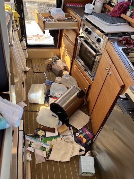
Note to self: Securing ALL loose items before getting into rough water can prevent a mess like this.
When it came time to make the 90° turn into the Bay River, I couldn’t do it — doing so would have put those big waves on my beam and there was a real risk of filling my aft cockpit with water. So I had to “tack” my way into the turn like a sailboat riding against the wind, zig-zagging until I was far enough into the river to shelter me from those big waves.
The whole ordeal took more than 3 hours and I still had to get across the Pamlico River and up the Pungo River to Belhaven. I was never so happy to be done traveling for the day. At the marina, I spent an hour picking up everything that had been tossed on the floor of my boat’s cabin and cleaning up dog puke.
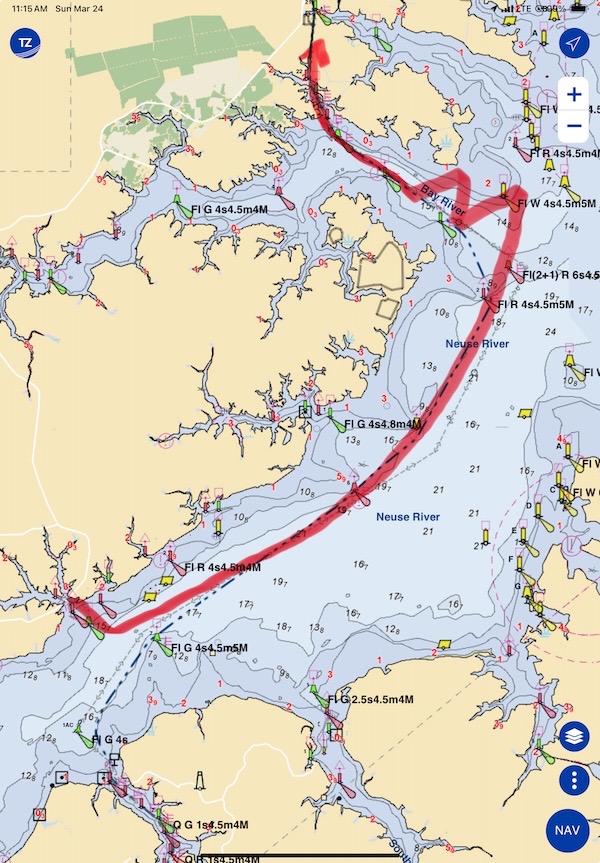
Here’s a general look at the route I had to take to get down the Neuse River and then into the Bay River. This chart is from the TZ iBoat app on an iPad.
(I need to mention here that it’s always a good idea to have a boat that can handle rougher conditions than you can. My boat is literally sea worthy — it is built to handle ocean conditions. It had no problem dealing with the Neuse River.)
I picked a better day this year. It was rough with 1-3 foot waves, but the wind and current were behind me. I was able to keep my speed up and get through it all, without making a zigzag turn, in a little over an hour. The Pamlico and Pungo were both kind to me, too.
From Belhaven, I’d have to go into the Alligator River-Pungo River Canal. I could then stop at the Alligator River Marina at the mouth of that river about 40 nautical miles away from Belhaven or continue on across the Albemarle Sound, which is the biggest body of water before I get to Chesapeake Bay, north of Norfolk.
There are two ways to get from the mouth of Alligator River across Albemarle Sound to the Norfolk area of Virginia:
- The Virginia Cut is favored by larger, faster boats, as well as boats with deep drafts and/or tall masts. It’s a combination of natural waterways and canal cuts that go through Coinjock and Great Bridge. There’s even a lock at Great Bridge. That’s the way I came south in October, mostly because I wanted to try the prime rib at Coinjock, which everyone raves about. (I was not impressed.)
-
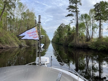
The Great Dismal Swamp Canal cuts like an arrow through a swamp that I don’t think is dismal at all.The Great Dismal Swamp Canal is favored by slow cruisers, including most Loopers, I think. It’s a slow route that runs from Elizabeth City through the Great Dismal Swamp’s canal and two locks. There’s a 5 mph speed limit in the main canal, which is also very narrow and shallow at some points. That’s how I came north last April and I absolutely loved it.
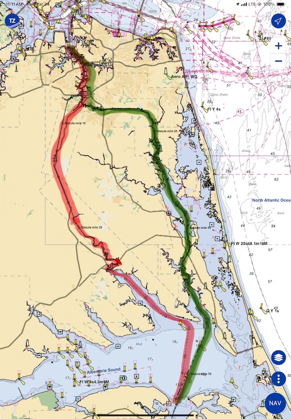
Here are the two different routes from Alligator River to Norfolk: green is the Virginia Cut and red is the Great Dismal Swamp.
I had already decided to go through the swamp. I loved it so much last year, I couldn’t wait to do it again. In fact, it was going to be the highlight of my trip north. With weather moving in on Saturday and apparently no other Loopers nearby to compete for the limited dock space at the rest area in the middle of the swamp, I felt pretty confident I could get a second day in its peace and quiet, hanging out on my boat until the rain passed through and I could continue north on Sunday.
So I left Belhaven on Thursday and did the 70+ nautical mile trip up the Pungo River, through the Alligator-Pungo Canal, down the Alligator River, and across Albemarle Sound. The two rivers were choppy, the canal was nearly dead calm, and the sound was a bit rough, with 1 to 3 foot waves. It wasn’t much worse than the Neuse had been the day before, but I could not go directly across the Sound to the Pasquotank River because I’d have to put those waves on my beam. So I kept a more northerly heading, putting the waves about 10° to 20° on my starboard bow. When I got about halfway across, the swells eased up — they were wind-generated from the north, after all, and I was getting closer to land. At that point, I was able to make my turn, go up the River, and stop at one of Elizabeth City’s three free docks for the night.
(In case you’re wondering, I chose the Jennette Brothers Bulkhead. I wanted to be on the other side of the draw bridge so I didn’t have to wait for it to open in the morning. I checked in as required, saw that dogs were not allowed, was told that it would be okay if I kept them leashed or on the boat, and promised to eat at one of the restaurants on their list. I ate at the Japanese place about 2 blocks away, Toyama Japanese. I recommend the restaurant; it was outstanding. But I don’t recommend the dock. With no protection on the vertical piers between me and the dock and a wind from the east, by boat banged against the dock all night. It was also loud by the bridge and the parking lot was very brightly lighted at night.)
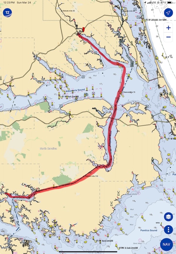
I covered more than 70 nautical miles on Thursday to get across Albemarle Sound before weather moved in on Friday.
This was perfect — or so I thought at the time. The weather for the next five days would get progressively worse with peak winds at gale force speeds on Sunday on Albemarle Sound. One of the weather models was predicting 10 foot waves. If I hadn’t crossed the sound when I did, I’d be stuck at Alligator River Marina for five days. And trust me: that’s one place you don’t want to get stuck at. But I was sitting pretty at Elizabeth City with the nice calm waters of the swamp ahead of me and an easy path to Norfolk. I even made reservations at the Hampton Town Docks for two nights starting Monday.
Friday’s Cruise to the Swamp
The locks on the Great Dismal Swamp Canal only open four times a day on a specific schedule. I was in no hurry, so I decided to shoot for the 11 AM opening at South Mills, which was about 15 mostly winding miles away. It would be a 2 to 3 hour cruise, depending on my speed. I wound up getting off a little later than I planned — almost 9 AM — so I had to do the trip at about 8 knots to get there on time. I used Aqua Map for trip planning and it told me exactly what time I’d arrive every time I changed my speed.
It was a pleasant cruise on the ever-narrowing river, which eventually shut down to a straight canal called Turners Cut. There were a lot of downed trees, but none of them blocked my path. I slowed down for the few houses along the narrowest part of the canal, trying to respect their No Wake signs even though they didn’t have any boats in the water.
I called the lock 3 miles out. No response. Too far. I called again a mile later. This time there was some static as someone tried to respond. I told whoever it was that I couldn’t hear them and would try again when I got closer. I kept going.
When I called again about a half mile out, the voice came through clearly: “The lock is closed until April 1.”
What?
I looked at Aqua Map, which always shows Waterway Guide navigation alerts. The woman at the lock — or at least listening to the lock frequency — said there was a Notice to Mariners about it back in December. Maintenance. But I could not find any notice about it on Aqua Map or Waterway Guide.
At least not at first. As I instructed my boat’s autopilot to follow our track in back out — heck, I knew it was a good track — I combed through the Waterway Guide website. Sure enough, if I set the Explorer feature to display Alerts (not locks or bridges or marinas), it was there. Literally, the last place I looked — and not a place I’d normally look. After all, navigation alerts normally appear right in Aqua Map. This one did not.
It was March 22. I was not going to wait 8 days for the lock to open. I couldn’t wait. I had a deadline. I had to get to Colton Point by April 4. I needed extra time in case weather on Chesapeake Bay delayed me. I couldn’t use up all my spare time waiting to get through the swamp.
Making New Plans
The first thing I did was contact Hampton Town Docks and tell them to cancel my reservation. I explained the problem and told them that I’d try to come later in the week.
Then I thought long and hard about the situation and my options, keeping an eye on where my autopilot steered us.
Because I couldn’t wait, it looked like the only viable option was going back down to Albemarle Sound and taking the Virginia Cut. But I couldn’t do it that day — even if the conditions were okay, there wasn’t enough time. And I couldn’t do it until the weather cleared out. In the meantime, I had to find someplace to wait out the weather, starting with the big rainstorm expected overnight and into Saturday. It would have to be a marina with power because there was no way my solar panel would keep up with my power demand in foul weather.
Isn’t it nice to visit a website that isn’t plastered with advertising or sponsor messages? Or trying to get you to buy merchandise or sign up for seminars? If you appreciate the (mostly) ad-free experience, how about buying me a cup of coffee to thank me?
I worked Aqua Map and found Lamb’s Marina. I remember someone telling me about staying there and how it was pretty good. (I later discovered that it had been Gold Loopers Ted and Kim on Pony last year.) I called. Did they have room for a 32-foot Ranger Tug for at least 5 days? Larry, who I suspect is the owner, said to come on in.
And that’s how I found myself staying at a combination marina/trailer park in Camden, NC, waiting out the weather, enjoying amazing hot showers, and hopefully getting stuff done.
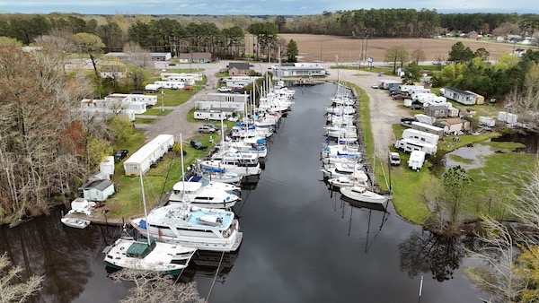
I sent my drone up for an aerial view of Lamb’s Marina. My boat is on the left side of the fairway, about 1/3 way down. It’s very difficult to see among the much larger boats.

So glad you got in at Lamb’s and didn’t have to wait out the weather at Alligator River Marina!
Me, too! I really like this place, despite its overall funkiness. I had the best shower I’ve had so far in the loop this morning: hot water that didn’t change temperature on its own, great water pressure, clean bathroom. I might shower twice a day while I’m here.
Just found your blog tonite. This was very helpful!
I’m very glad to hear it! Thanks for taking the time to comment. It sure does motivate me to keep writing.
Why didnt you go to Sanford. I cant find your next leg on the st johns post.
I didn’t think it was worth the extra day. Sorry!
As for the next post in the series, well, there are only so many hours in a day and I’ve been trying to spend fewer of them in front of a computer. I might get to it eventually. My trip to Silver Spring was quite remarkable.