January 8: I cross the northeastern corner of the Gulf of Mexico with buddy boat Pony.
(continued from Apalachicola to Carrabelle, FL)
I was up at 4 AM, long before my alarm went off. I had a lot on my mind. First and foremost was the Gulf crossing, which was one of the big Looper challenges in any boat, but especially in a smaller boat like mine. And, of course, there was the tide situation; I’d have to move my boat forward in its slip before the tide went out or I’d be stuck in the slip until the tide came back in.
Lying there in bed, I thought about these things. And then I fell back to sleep.
Dealing with Low Tide
The alarm went off at 5 AM and I nearly jumped out of my skin. I reached for my phone and checked the tide information. It was going out but still about two hours away from low. I had some time, but not much.
Outside, it was dark with no sign of dawn.
I went to the helm and fired up my chartplotters. They’d tell me how much water was actually under the boat. While they fired up, I got my coffee maker going. Then back to the chartplotters. The depth was 0.5 feet at the boat’s stern, where the transducer is. While that seems scary, remember that I have about 3-4 feet of wiggle room in there. So that meant I was in about 3 1/2 to 4 feet of water. My boat needs 2 1/2 feet to float. I needed to move the boat before the tide went out much farther.
Keep in mind that once I moved the boat, I would not be able to get on or off it. I simply would not be able to access the comically short finger pier between my boat and the large sailboat beside me. That meant I had to walk my pups and disconnect shore power before actually moving the boat.
I sprung into action, turning on the light in my sleeping area and dressing. My pups were still sound asleep on the bed. When I was dressed, I woke them and fed them. They seemed a little baffled, but they ate the food I put in front of them.
Once they’d eaten, I lifted them up onto that treacherous finger pier, which was now high above the boat’s gunwales. With a little effort, I followed them out. It only took one misplaced step to remind me that the end board was loose.
They did their business, I scooped the poop, and I hustled them back to the boat. I had to pick up each dog individually and carry her down into the boat; there was no other way to get them down there safely.
Then I went back and disconnected the shore power. I bundled the heavy cord together and got it back on the boat by simply tossing it into the aft deck.
Then back to where the two stern lines were cross tied to the top of the sea wall. I had to do this carefully; if the boat started to drift out without me, I wouldn’t be able to get back on. I tossed the starboard line onto the back deck but held onto the port line, holding the boat back as close to that little finger pier as I could. Then I carefully stepped back onto the boat and dropped the line at my feet.
The boat was already drifting forward, but what was worse was that it was also drifting sideways, into the sailboat on my port side. The current was wicked strong as the river and tidal water was flushing out to the bay. Fortunately, both the sailboat and my boat had fenders down. So when my boat gently swung into the sailboat, there was no thud or chance of damage.
I moved to the bow where the two lines had been looped around the posts at the outside of my slip. I tightened the lines, one after the other, to pull the boat closer to the river. I tried tightening the line on the starboard side so that it would pull the boat away from the sailboat to port, but all that did was pull the bow away. I was now at about a 30° angle in my slip with the bow of my dingy touching the sailboat while my boat’s bow was nearly touching the starboard post. This was not ideal, but it was what it was. Nothing was going to get damaged and my boat wasn’t going anywhere.
But my mission had been accomplished: I was 10-15 feet away from the sea wall behind me. When I looked at the depth finder gauge, it registered just over 3 feet — or 6 to 7 feet including my wiggle room. The tide would only go down another foot or so so I was good.
By the time I did all this, it was getting close to 6 AM. We’d planned on a 7 AM departure. It was time to wait.
What’s the Big Deal about Crossing the Gulf?
I should mention here that crossing the Gulf of Mexico in a small cruising boat is a big deal. Unless you like being tossed around all day by waves, you need to wait for a weather window when the wind and waves settled down for a calm water crossing. Boats gather in Carrabelle or nearby Dog Island anchorages and wait for that window. Sometimes they wait a week or more.
While it seems as if we didn’t have to wait — after all, we were departing the day after we arrived in Carrabelle — it’s because we timed our arrival in Carrabelle to correspond with the first day of a three-day weather window. We could have gone the day we arrived, the next day (which was when we were going), or the day after that. Beyond that, things got sketchy again for a while and we’d have to wait.
How did we know about the weather window? By consulting a lot of weather resources and listening to what other cruisers were saying. I consulted the Windy app on my iPad to get wind and wave information. I also looked at National Weather Service (NWS) data. I didn’t just do this day before. I did it every day for about a week. Weather forecasts change and its important to monitor them.
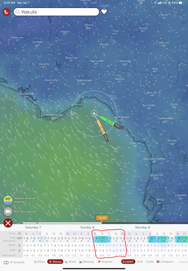
Here’s what the Windy app was telling me the day before we left. Note the circled area in the table at the bottom of this screen shot. These are the conditions we were expecting.
So we didn’t get lucky with our arrival as much as we planned better than some folks do. After all, we knew this weather window was coming when we were as far away as Panama City so we had plenty of time to plan our arrival in Carrabelle. Although the previous day might have been a little better, that day was good, too.
Waiting to Go
While I waited, I reheated my coffee in the microwave and drank it. My pups had gone back to bed.
Over time, the sky brightened. I took a photo of the moon setting to the west, beyond the marina.
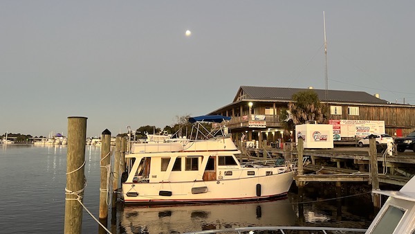
Moonset from the bow of my boat.
At around 6:30, I texted Kim to make sure they were awake. They were, but they wouldn’t be able to leave at 7. They needed to get fuel — there had been a wait at their marina the previous afternoon, too, and with the crazy current they’d decided to just dock and get fuel in the morning. But the marina wasn’t open until 7 so they had to wait.
So I kept waiting. I had breakfast. I checked Nebo and saw the long line of boats already on their way to Tarpon Springs or Clearwater.
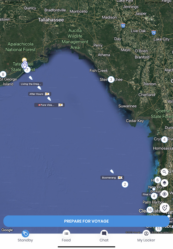
Here’s what the Nebo app was showing me that morning. You can see individual boats by name and also groups of boats as numbers in circles. The conditions were perfect that morning and many boats were crossing over.
A little after 7, I heard from Kim again. They’d left their slip and were heading for the fuel dock.
I started the boat’s engine, spread my pups’ blanket on the inside helm seat where we’d be sitting, and put them on the seat. Then I started to think about how I was going to retrieve the bow lines, get back into the boat, and steer it away from the slip without getting wedged sideways in it.
Leaving Carrabelle
When the time came, it was easier than I expected. I pulled off the port side bow line first — after all, it really wasn’t doing much. Then I pulled off the starboard bow line, ran down the gunwales, and dashed back into the cabin. The thrusters were already turned on. I used the stern thruster to straighten the boat in the slip: a long push to starboard. Then a few quick taps of the bow thruster, since the bow was moving with the current to port, too. When I felt as if the boat was nearly centered in the slip, I pushed the throttle forward and the boat moved out into the river.
Pony wasn’t ready yet, though. It was still at the fuel dock at The Moorings a bit up the river. I idled in the current for a few moments, then put the boat in idle forward and steered toward the bay. I used heading hold to get it pointed in the right direction.
A huge sport fishing boat came up behind me. I got its name from AIS — it was a weird name that I can’t remember. I got on the radio and told it to pass. He passed at a slow speed that still waked me. Those boats move a lot of water.
Then Kim was texting me that they were on their way. I waited until they were behind me before speeding up. By that time, we were in the bay outside the Carrabelle River. I let Pony pass and got in behind them.
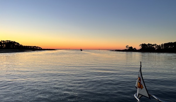
Kim sent me this photo out the front window of Pony as they headed down the Carrabelle River toward the bay. Do It Now is the dot in the middle of the channel on the horizon; if you look closely, you can see my windsock high on its pole.

Kim took this great picture of Do It Now from Pony as they passed. It looks so tiny on the big body of water.
Crossing the Gulf
There is no channel to cross the Gulf of Mexico. Once you leave the Carrabelle River, all you have to do is go around Dog Island, which protected Saint George Bay from the Gulf, and point your boat’s nose toward your destination. There is a channel that goes to the west end of Dog Island, but we were going east so it would be silly to go west. Ted set a course due east and I followed.
It wasn’t long before we heard a very angry exchange on the radio between someone anchored near Dog Island and that huge sport fishing boat that had passed me in the river. Apparently the sport fisher had gone full speed past the island and rocked the boats anchored there so badly that the man on the anchored boat had spilled his morning coffee all over himself. The sport fisher captain, who had actually identified his boat when the initial call came through, got quiet as the coffee-drenched boater read him the riot act over the radio and asked again for the boat name. No response.
This, it turns out, is typical for too many boaters in Florida. They really don’t give a shit about how much wake they throw up and how it affects other boaters.
Going east around Dog Island did put one obstacle in our path: a long area of shallow water, like an island that had never quite made it to the surface. On my Aqua Map plan for the day, I’d expected to go north of it, but I soon saw that Pony was headed straight for it. Before we actually got there, however, Pony slowed and made a sharp turn to starboard, heading south. I followed as it threaded through a deeper water gap in the shallows and then headed east again.
Soon I was having the same problem I’d had the day before. Pony didn’t steer the kind of straight line you’d get if you put the boat on heading hold. Its speed seemed to vary, too. I kept finding myself in its wake or getting too close or slipping farther away. I now know — based on the comment Kim left on yesterday’s blog post — that it was likely Kim and not Ted who was driving. Although Ted uses heading hold like I do, Kim does not. Of course, I didn’t know that then. All I knew was that I couldn’t spend the day following them if it meant a lot of course and speed corrections.
So I zoomed my chartplotter, found the first channel marker into Steinhatchee, tapped it, and tapped Go To. When I engaged the route, the boat shifted course slightly to port and made a beeline for that channel marker 50+ miles away.
My notes say I had the RPM set to 2760 which gave me about 12 knots burning 9.3 gallons per hour for a fuel economy of 1.3 mpg. Pony must have been doing about the same speed because although our paths drifted apart by a mile or more, I never really got ahead or behind them. They were always in sight, off to my starboard side. I texted a bit with Kim but when the cell signal abruptly cut out, even that ended.
We lost sight of land, too. It was the first time I’d been alone on a boat out of sight of land. But it didn’t bother me as much as I thought it would. First of all, the Gulf was dead calm so the ride was smooth. Second, Pony was in sight off to my right. Third, I knew that if I needed to see land, I could turn to the north and it would likely come into view within a few minutes. But if I just stayed on course, it would come into view soon enough in front of me.
And it did. I think I was only out of sight of land for about two hours, maybe from 10 AM until about noon.
I listened to an audiobook on the boat’s stereo while I motored along. There wasn’t anything else to do. And I snacked. I usually keep string cheese sticks and Cuties mandarin oranges on board. And it’s easy enough to spread some almond butter on a cracker while I’m sitting at the helm. Getting food into my body was never much of a problem.
The cruise was boring — which is fine when you’re crossing a large body of water. I like boring in that situation. The autopilot took care of keeping us pointed in the right direction. There were no obstacles to steer around — at least not while way out in the Gulf. I just sat in my seat at the helm, snacking and listening to words I couldn’t read on a page or tablet while in motion, with my two pups stretched out on the seat asleep beside me.
Off to the south, going the same way I was, I could see Pony and imagined Kim and Ted chatting or snacking or both. Or one driving and one napping. One of the big benefits of driving with a suitable companion is being able to take a break while the companion drives the boat — if her or she wants to. When I’d crewed for Captain Paul in 2021, he’d set up a 2-hour rotating shift and would nap when he wasn’t at the helm or on watch.
Dodging Crab Pots
Not long after land came back into sight, the crab pots started up.
Commercial crabbing is a big thing on the east coast. Crabbers have large traps that they drop over the side of their boats, leaving a small buoy, usually bigger than a softball but smaller than a soccer ball, floating on a nylon line to mark the location of the trap and give the crabbers a way to pull the trap back up. (I call them crab traps but most folks call them crab pots so that’s what I’ll try to call them here.)
The buoys can be round or bullet shaped. They can be any color — I’ve seen them in white, yellow, red, blue, and even green — and can be easy to spot in good conditions or damn near impossible to spot in bad ones. If you run over a crab pot buoy in just the wrong way, its nylon line will get caught up in your prop, bringing your boat to a standstill until you remove it, normally by taking a dive under the boat. This is not something I ever want to do.
One of the reasons the overnight cruisers time their arrival on Florida’s Gulf coast for around 10 AM is so that there isn’t sun glare on the water surface as they arrive in the crab pot area. The sun shining off the water is one of the conditions that make seeing the little buoys nearly impossible.
Seeing the first crab pot was like throwing cold water in my face. I had been paying attention with nothing to grab my attention. Now I had something to grab my attention. A lot of somethings.
In this area, there was definitely a pattern to the crab pot buoys and I could imagine how that pattern was achieved. Imagine a flat-bottomed boat with two guys on board and a huge stack of baited crab traps. One guy drives the boat in a straight line while the other guy heaves the traps off the boat one at a time. The result is a line of buoys with space in between them.
So if you saw one buoy, you could usually see one more near it. Following the line the two buoys made, you could see others, all on that line. Once you saw them, you could steer between them.
This was easy when the crab pots were on a path perpendicular to yours. But they didn’t all go in the same direction. They went in all different directions. Sometimes they even crossed paths. Spotting them that day wasn’t difficult — we had calm water and the sun was overhead so there was no glare. But the closer and closer I got to shore, the more and more of them I spotted.
Of course, the autopilot didn’t see them, so it was pretty useless. I put it in standby and did some hand steering, returning to the magenta course line on my chartplotter — or one that paralleled it — as often as I could. It was not fun. Whenever I thought I was finished with them and put the autopilot back on, another row of them would appear. It made the last hour or so of the cruise very tedious, to say the least.
Getting to Steinhatchee
As I got close and closer to the first marker for the channel into Steinhatchee, Pony got closer and closer to me. We were, after all, going the same place.
I can’t remember — maybe Kim can? — who got into the channel first: Do It Now or Pony. In any case, passing that first channel marker and getting into the channel was a relief: there were no crab pots in the channel. It also meant our nearly six-hour journey was coming to an end.
The channel headed straight toward land and then made a few little zigzags as it the Steinhatchee River. I stayed between the markers. Made a call to the marina when I had it in sight and was directed to a slip with a long side pier. For some reason, I backed in; there must be a reason why but I don’t remember it. I had plenty of room so I didn’t go back all the way, leaving about six feet behind my boat. Pony got tied up in a slip closer to the river.
We had arrived. One of the parts of the trip that had most concerned me — crossing the Gulf of Mexico — was over. And due to good planning, it had been a non-event. We had gotten across the Gulf in just six hours, cruising at an average speed of nearly 12 knots. It would be another two hours before the next boats from Carrabelle arrived.
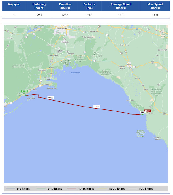
Here’s my Nebo log for January 8, 2023. Download a PDF log file with more info. Track Do It Now on Nebo.
What I didn’t realize then was that my dealings with the Gulf of Mexico weren’t quite over. I still had to get down Florida’s west coast from Steinhatchee — and there wasn’t a nice, sheltered Intracoastal Waterway until after Tarpon springs, another 80 or so miles away.
My planned three-night stay in Steinhatchee would be considerably longer than I expected.


I am remembering how long you stayed in Steinhatchee.
Did you ever get to eat some of those Gulf crabs? Besides seeing my sister, the best part of visiting St. Pete is the stone crab claws.
No, I didn’t. I waited, expecting to get them in the Keys. But then I didn’t go to the keys. It’ll have to wait until next winter.