December 10, 2023: Another long day on the Tenn-Tom.
(continued from Pickwick Dam, TN to Fulton, MS (Midway))
Another morning, another marina along the Great Loop. It was dark when I woke (as usual) but brightened as I had my coffee in bed with my pups. Outside, after a somewhat promising sunrise, it was quickly shaping up to be another gray day. I was starting to get depressed.

Sunrise at a pond near the restaurant at Midway Marina. The clouds thickened before we departed.
First Lock
My friend Kim on Pony had warned me that there was a lock just beyond the marina and if it wasn’t ready for us, we could spend a lot of time waiting for it. (I knew that story well.) She’d advised me to call ahead to the dam and see when they could take us through. Of course, I also had the ability to check AIS and see if there were any tows in the area. There was definitely one moving south and I wasn’t sure if the lockmaster would let us through before it.
So with our morning stuff, including breakfast and feeding/walking my pups, all done, I got on the radio and called the lock. The lockmaster told me that if we could get there within 30 minutes, he’d lock us through. That was doable so I told him we were on our way.
I don’t think I ever prepped the boat for departure so quickly. Engine started, power disconnected, power line stowed. Alyse had us cast off as soon as the engine reached 100°F. We glided away from the marina, past the dead trees coming out of the water and into the channel. Then I pushed the throttle forward and we moved quickly to the dam, which was just a few miles away.
True to his word, he had the lock ready for us when we arrived. I maneuvered us into position, Alyse secured a line around one of the floating bollards, and we started our journey down with the water. We were becoming locking pros.
Another Long Cruise
We settled in for our long cruise, which would cover more than 50 miles, take us through four locks, and, if all went well, bring us to Columbus Marina. It was very much like the second half of the previous day, with lengths of mostly straight, narrow canal leading into wider lakes, ending with a dam, and then starting all over again downstream from the dam. There were occasional tows to pass and all of the locking went relatively quickly.
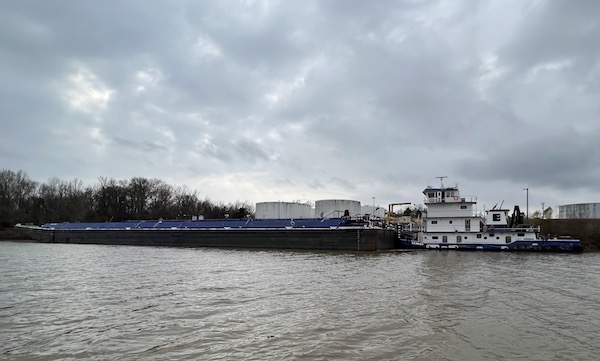
Yet another tow, this one parked alongside a loading facility. The tows were definitely smaller here than they had been in the Illinois, Mississippi, and Ohio Rivers.
I don’t recall passing any other pleasure craft. ChaoCheeBai (“the Chinese boat”) which had parked beside us at Green Turtle Bay was far behind us, delayed mostly by weather. Patrick in Endeavor and was days behind us; he’d had a late departure from Clifton because of fog. Resolute from the previous day was just a bit behind us but would not catch up. My friends from October were far ahead of us and although we kept in touch daily via text messaging, I felt left behind. I wanted more than ever to catch up with them.
But I had to play the cards I was dealt and that meant slugging along at about 8 knots on yet another cloudy day, winding my way through the canal and lakes and locks to get ahead.
Now it might sound as if I were not enjoying myself. It’s weird. I was and I wasn’t. I liked the driving and even the relatively boring late autumn/early winter sights around me. But I wasn’t as excited about the trip as I had been in the past. I really think it was a sort of depression that had come over me, fed by the weather, our almost fevered drive every day pace, and the lack of things to do at our destinations. I suspect Alyse felt the same way because she certainly didn’t seem happy about anything and that was wearing me down, too.
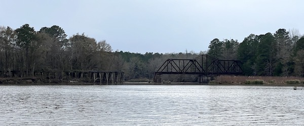
Scenery like this long-abandoned and broken railroad trestle doesn’t do much to raise a person’s spirits.
Crazy Ivans
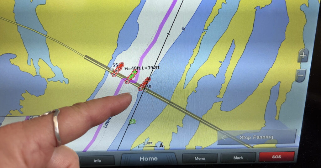
To make the going more interesting, I decided to spend some time working with the auto guidance feature of my chartplotter’s autopilot. We were in either a canal or a channel through a lake most of the time. I’d tap on the screen right before a lock up ahead and tell the chartplotter to give me an auto guidance route to it. It would think for a while and then lay down a pink (magenta?) line on the chart and warn me that there were hazards along it. I’d tap the right spot to review the hazards and find that there were dozens, if not more than 100 of them. I’d start reviewing them and they’d be the same thing over and over: course comes close to a channel marker. After about a dozen of those, I’d assume they were all the same and just activate the route. It wasn’t as if I were going to walk away and let the boat drive without supervision.
The autopilot would take over all the turns and I’d sit there looking ahead. Every once in a while, it would let out an annoying repetitive beep as it approached one of its “hazards.” In every case, we didn’t come close enough to the channel marker it was worried about for me to need to take action. I’d just tap the OK button to shut it up and we’d keep going. It was annoying, to say the least.
And then we got to a bridge and the boat made a hard turn right toward one of the concrete supports.
What the hell?
I punched the red Standby button, took the wheel, and steered us back into the middle of the channel. I looked down at the chartplotter screen, zoomed in, and saw that, sure enough, the pink line did a zigzag that might have caused a crash if I hadn’t taken action.
That was weird and definitely dangerous. But it must have been a fluke. So I got the route started again and let the boat steer. More beeping at imagined hazards. Until the next bridge when the boat made another hard turn toward the bank.
Crap!
I punched Standby and took over. This was seriously screwed up. I tried resetting the auto guidance route, but the same thing kept happening at almost every single bridge we went under. Something about the bridges confused the auto guidance system.
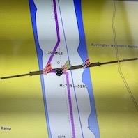
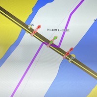
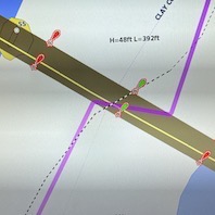
Here are three examples of the auto guidance route trying to kill us at a bridge. See the sharp turns in the pink line? We started calling them “crazy Ivans” (kudos to you if you get the reference).
And did I mention that the system never beeped about a “hazard” before making one of these sharp turns?
I continued to experiment with the system for the rest of the day. Whenever I’d see a bridge up ahead, I’d zoom into the chartplotter’s route line to see whether another attempted murder was in store for us. For most bridges, that dangerous zigzag was clearly indicated. I’d turn off the autopilot, guide us safely under the bridge, and then turn it back on.
Of course, I contacted Garmin about this. They gave me some bogus excuse about the chart not having enough detail about water depth to plot a route. If that was the case — if the auto guidance feature was incapable of creating a safe route when insufficient data was available — why did it create a route at all? But I knew it wasn’t the case. The depth data, as well as channel markers, was all there. I could see it. And Garmin wasn’t in the least bit interested in working with me to troubleshoot the issue. They just blew me off.
Over the weeks to come, I’d discover more and more shortcomings in the auto routing feature of my Garmin chartplotters. And I have to say that it pisses me off to no end, mostly because I updated the chartplotters and bought additional data cards from Garmin just to be able to use the feature on my four-year-old system. Lesson learned.
Milestone
My notes don’t have much about the trip other than the locking went well. Except one thing.
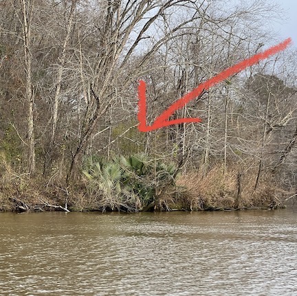
I like to think that this wasn’t really the first palm tree that we passed. That it was, in fact, just the first one I saw.
At mile marker 345 we saw our first palm tree on the port side of the boat. I took a picture. I had to put an arrow to mark it when I shared it with others.
This reminded me of drives from New Jersey to Florida when I was a kid. It was always a sign that we were south, in the land of warm weather when we started seeing palm trees.
Of course, there was no change in the dreary weather.
Arriving at Columbus
We arrived at Columbus Marina around 3 PM. It was a relatively tricky approach.
The woman on the radio instructed us to go toward the lock just past the marina and turn at some yellow-painted mooring cells. Then we had to stay in the channel, favoriting the red marker until abeam the fuel dock. Then a 90° turn inbound, hugging the fuel dock all the way into the slip area. She told us to pick a slip and, by the time I was easing us into one, she was at the dock, ready to grab out lines. She was incredibly helpful getting us docked and our power hooked up. I gave her a tip, which I think surprised her.
As usual, I started our stay by taking my pups for a walk. I’d planned to stay at the marina for two nights. I was looking forward to a rest.

Here’s our Nebo log for December 10, 2022. Download a PDF log file with more info. Track Do It Now on Nebo.
(continued in At Columbus Marina)
