December 7, 2022: Another day with lots of fog and a near miss with an invisible tow.
(continued from Buchanan (Paris Landing) to Waverly, TN (Cuba Landing))
It started pouring like hell before dawn. We were in a covered slip at Cuba Landing, so it didn’t hit the boat. Instead, it pelted the metal roof over us and poured down into the lake just beyond our slip’s end. It was a sound I was somewhat familiar with, living in a house with a metal roof. I like the sound of rain and I like waking before dawn, so it was all good.
We did our morning thing, including a walk with my pups in the rain outside the covered dock. There were deer in the woods again, but they ran off before my dogs could see them. (It’s probably pretty hard to see things in the distance when your eyes are only 6 inches off the ground.)
In addition to the rain, there was patchy fog, but it wasn’t much worse than what we’d started the previous day in. I didn’t care. I just wanted to leave. I felt an urgent need to keep moving, to get as far south as we could as quickly as we could. I wanted to escape this dismal weather. I was tired of cold and rain and fog.
I had no idea then how far we’d have to go.
Leaving Cuba Landing
By around 8 AM, we were ready to go. Alyse cast us off and I backed out of the covered slip and into the rain-splattered little bay the marina sat in. I followed our GPS path in, which clearly showed on my chartplotter, to get back out. There was a tense moment when I spotted a fishing boat in the fog and thought it might be in the channel. It wasn’t. We passed them by and I thought about the foggy morning in the Erie Canal a year before when the fog had been worse and the fishing boat had be in the channel.

Pouring rain and patchy fog? Some guys are way too serious about fishing.
We followed the channel downstream, relying on the chartplotter and radar to keep us in the channel and aware of our surroundings. I moved very slowly — 5 to 7 knots — for most of the day. It got us great fuel efficiency, but the day dragged on. After we passed a large floating log — the kind that can seriously screw up your boat if you hit it — I asked Alyse to help me keep an eye out for other obstacles. Although she was sitting in what Captain Paul had called the “watch seat” and it was technically part of her job to keep a watch with me, she was bored and spent a lot of time on her phone. The log spooked me and I wanted another pair of eyes on the water. Kim and Ted in Pony, who were quite a way downriver from us, had reported days when they dodged debris all day long.
One of the things I noticed on my radar display when laid over a chart was that the land echoes didn’t line up with the actual land. I fiddled around with the radar settings and found an adjustment that lined them up properly. But I discovered later in the day that the alignment changed based on the direction we were moving. There was no “correct” setting. This might be because I’m a “north is up” chartplotter user where most other folks I know are “track is up” users. But I wasn’t going to change my preference in chart viewing just so my radar lined up better. I’d deal with it as is.


Here’s my radar overlay screen before (left) and after (right) adjustment. Note how in the left image, the radar echoes of land go out over the water but don’t do that in the right image. This was a temporary fix that only worked when I was moving in that direction, so I went back to the default setting.
When the fog lifted a little, I sped up a little. But not much. I think I was mentally still in fuel-saving mode.
Around 10 AM, I decided to give the Autorouting feature another try. I programmed in our destination — Clifton, TN — and let it create a route for me. Then I engaged the autopilot and let it do the driving while I looked on. The experiment didn’t last long; I turned it off as soon as we got into yet another foggy area.

Here’s what my helm setup looked like that day. From left to right, top to bottom: iPhone 8 Plus (a spare phone) running Nebo, iPad Air running Aqua Map, Volvo engine computer screen, Garmin AutoPilot screen displaying an active route, and two chartplotter screens, each with different magnifications and the one on the right displaying a radar overlay.
We passed a bunch of tows, all going down river. In each case, the tugboat appeared on AIS and I was able to call and arrange to pass. I lucked out on the timing because we were in a light fog area for each pass.
A Close Call
A little after noon, we were in a heavy fog area and I saw an AIS target on my chartplotter. I used the Info feature to get its speed and discovered that it was a parked dredging operation. Soon I saw the top of its crane above the fog. No worries. I called to say I was passing on the outside of the curve. A one whistle pass.
And that’s when a small tow suddenly appeared out of the fog, moving toward me. I slammed on the brakes — well, the boating equivalent of that since there are no brakes on a boat: throttle to neutral and then to reverse to stop forward motion.
I looked at my chartplotter. I could see the AIS target for the dredge, which was now visible off the port side. But that was the only AIS target. This little tow with its little barge full of dredging spoils did not have AIS!
I checked the radar. Sure enough, a target appeared there. But it hadn’t been there a while ago. The smaller tow had apparently been parked with the bigger dredging tug and barge and its echo merged with that one. It wasn’t until it started moving that it created its own radar target.
And did I mention that no one was sounding any horns?
He passed in front of me and began moving up my starboard side, upriver. He was a safe distance away, but I’d still been seriously spooked. I started moving again, cursing my naivety. Of course there would be tows without AIS or with AIS somehow turned off. I needed to be more vigilant and not assume they’d all appear on the chartplotter.
At Clifton
There was still plenty of patchy fog when we arrived at Clifton Marina just after 2 PM. We’d been on the water for more than 6 hours and had gone only 37 nautical miles. (Sadly, I don’t have a Nebo log to share for this day.)
It was good to be done driving in the fog. It’s totally exhausting to be on high alert for hours at a time. I hoped the next day would be fog-free.
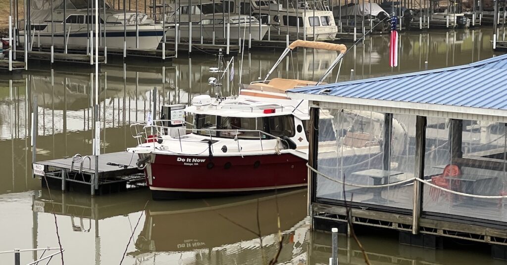
I parked at the fuel dock to top off my tank. Afterward, they relocated us to a slip right in front of the restaurant/bar on the other side of the fuel dock.
We went into the restaurant for lunch. Kim and Ted on Pony had raved about the restaurant, but I didn’t see what was so special about it. There was a small menu with the usual kind of cafe food: burgers, fried fish, salads. A television on the wall was playing Home Alone 2 and everyone who worked in there was totally engrossed in it. I had a burger and it was good enough, but nothing special. Alyse had some fish and was similarly unimpressed. It turns out that the meals to eat there are either breakfast or dinner when the main chef was there. She was gone that day, on a day trip to Knoxville — what is it about Knoxville that so many people were going there? — and would be back the next day. When she was cooking dinner, there was wild game and rack of lamb on the menu. We’d miss all that.

This was Clifton Marina’s courtesy car. Any car is better than no car, even when there isn’t any place to go.
We borrowed the courtesy car, which was a church van in terrible condition. It made some sort of weird grinding noise as it drove. We drove through town to check it out and were seriously disappointed. There wasn’t much there and what was there was closed — on a Wednesday afternoon. We were looking for groceries but the best we could do was a Dollar General, which, in this area, sells food. We followed the directions given to us by the folks in the marina — or thought we did. We wound up going the wrong way for about six miles, looking for the “highway.” We then realized that we were on the highway we were looking for. We went back and found it less than a quarter mile in the other direction. We bought some things and went back to the boat with the rest of the day to kill there.
I don’t remember how I killed that time. I probably read. Alyse probably did, too. I know I took my pups out a few times. I walked to the river to take a look and it was still foggy out there.
On a visit to the marina office, I met Patrick, the owner of Endeavor. Endeavor was a Cape Dory Power Cruiser about the same size as my boat that had come in while we were on our Dollar General Adventure. He was cruising solo; his wife didn’t want to come. (Seriously, ladies? What’s with that?) We chatted for a while about martinis and food. He was apparently a bit of a gourmet. I wish I could hang out with him so he could cook for me. I was starting to get seriously tired of my own cooking.
Home Alone 4 was on the television. It had a different kid.
When it got dark, some folks showed up at the restaurant/bar. There was a screened in area adjacent to the boat. I could see a television on and a few people eating. I wondered how a place like that could stay in business. We didn’t join them, though. Lunch had been enough food for us late enough in the day.
So we turned in early. Again.
(continued in Clifton to Pickwick Dam, TN)


Fog! UGH!!
Spoiler alert: we had fog four days in a row. I got over my fear of driving in it.