November 28, 2022: We make a relatively short trip to the famous Hoppie’s fuel stop.
(continued from Return to Do It Now)
I should mention here — I’m not sure if I already mentioned it elsewhere — that my boat has AIS receive. This is a feature of my Garmin chart plotter system that taps into data transmitted by other boats and displays them as little green triangles on my chart. Commercial vessels, like tugboats pushing barges — known as tows — are among the boats that are required to have AIS transmit so they are displayed. Other vessels can get the equipment to transmit their own data and will also appear on AIS for those who can receive it. (I’d like to add this feature to my boat so other boats can “see” me when I’m still out of sight. I’m waiting for the Coast Guard to finish processing my boat documentation credentials, which I need to apply for the all important MMSI number that gets programmed into my boat’s systems for AIS transmit.)
The point is, I can “see” tows on the river long before I make visual contact with them so I do have an idea of what’s on the way to a lock I’m approaching.
Like Janet’s second travel day nearly seven weeks before, Alyse’s first travel day started almost immediately with a lock. I’d called ahead from the marina once I was ready to go and I was told that if we got there quickly, we’d be able to get in before an approaching tow. Needless to say, I hustled us out of the marina as quickly as I could.
Locking Down
I don’t remember much about that first lock on the Mississippi — the Mel Price Locks — I can’t even remember which of the two chambers they put us in, although my brain is telling me now that it was the larger chamber. Not remembering tells me it was a non-event. I apparently told Alyse what to expect, got the boat next to the floating bollard so it was easy for her to reach, and coached her through the process of looping the rope over it and holding on as water was released from the chamber and we locked down.
I do remember some problems with the fenders not being adjusted quite right on that first day and we eventually resolved the problem by setting up the fenders on the port side for locking and on the starboard side for docking. (This is something that would serve me well when I was cruising on my own.) The key, of course, is to position those fenders — I have four on each side, which I know is a bit excessive — so they protect the boat from whatever it’s up against. Lock walls require the fenders to be high, along the boat’s rub rail. Floating docks usually require the fenders to be much lower, especially the ones closest to the bow.
The gate opened, the horn sounded, and Alyse released the line. We continued down the Mississippi.

You’d have to be blind to miss this sign and seriously uninformed to not look for it.
I didn’t even really take note of the Missouri River joining the Mississippi a short distance later. I was too focused on the fork in the river we’d have to take to avoid the Chain of Rocks rapids and dam upstream from St. Louis. Apparently some folks miss this turn and head straight for disaster; a 44-foot sailboat was stuck there for weeks in October 2021. There are lots of stories and I didn’t want to be the subject of a new one. It turns out that the fork in the river was hard to miss, with a huge sign at the fork pointing the right direction. We followed the arrow into the narrow, 8.4-mile Chain of Rocks canal.
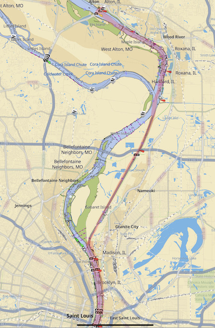
An Aqua Map display of our route between Alton and St. Louis. Note the long, straight canal to bypass the Chain of Rocks rapids and dam.
Of course, the big challenge here would be passing tows — the canal was very narrow and the tows in the Mississippi River were notoriously large. But because the canal was absolutely straight and the tows were all moving toward us, it wasn’t difficult to pass at all. Just call on the radio to establish which side you’re passing on, and maintain speed on the correct side. My notes say we passed three tows, all going upriver. We’d already been warned that if they were going the same direction we were going it made no sense to pass them since they’d definitely get into the lock before us anyway.
Again, I don’t remember much about locking through the Chain of Rocks lock so it must have been a non-event. We emerged on the downriver side of the lock and re-entered the Mississippi River.
Down the Mississippi
The next point of interest was St. Louis and, frankly, I think that city is missing out on an opportunity to draw in tourists by water. There are two barges along the river right by Gateway Arch; one is a dock for a riverboat that apparently does tours and the other is a landing area for a helicopter tour company. Why isn’t there a dock for pleasure craft coming down the river? With the Arch, other tourist points of interest, and some pretty darn good restaurants walking distance from the shore, I’d bet that plenty of Loopers would stop along the way past for a few hours spending money in the city. Yet there is no docking facility at all and, with the stiff current, it’s difficult to even pause along the way. A lot of the guide books also warn about heavy tow traffic in this area, but there wasn’t much at all when we were there.
I got some good photos of the Gateway Arch from the river as we passed. I was told that there’s a webcam on the Illinois side that takes pictures of boats as they pass the arch, but try as I might, I could not find a photo of us on any webcam site. Of course, we had no buddy boat — we were the only pleasure craft on the water on that November day. In fact, we were in the only pleasure craft I’d see along the way until we got all the way to Green Turtle Bay in Kentucky several days later. It sure looked to me as if we were the last of the year’s Loopers to head south past St. Louis.

Here’s a shot of the Gateway Arch from the Mississippi River. It would have been nice to have a photo of Do It Now with that in the background.
I don’t have any more notes or photos of the trip down to Hoppie’s Marine Service, which would be our stop for the night. I have vague memories of the river being a lot more deserted than I expected it to be. Maybe it was because it was the Monday after Thanksgiving. Or maybe it was because the Mississippi was still struggling with low water issues. I don’t know. All I remember is the miles going by on a cold, gray day with no leaves on the trees and no sun.
Arriving at Hoppie’s
It was about 1:30 PM when we arrived at Hoppie’s Marine Service.
Hoppies is a sort of legendary stop on the Great Loop and just about everyone doing the Loop stops there. The main reason is because it’s the last place to get fuel between it and Paducah, KY — a distance of more than 200 miles. (One of the factors that determines whether your boat can do the Loop is whether it can travel 204 miles on the fuel you have on board.)
The facility is interesting. It consists of a few barges strung together and anchored just far enough off shore that pulling up alongside it gives boats the depth they need to tie up. Cables attach it to land and there’s a ramp from one barge to the shore. One of the barges is for fueling and has gas and diesel pumps, as well as a shack you have to walk through to get from one barge to the next. (They must have a good business selling gas cans because that shack had about a dozen brand new 5 gallon plastic ones waiting to be sold and filled.) There’s a lot of dirt and a lot of rust. There are holes in the top of the barges with metal plates thrown over them so you don’t fall through. And, miraculously, there are power pedestals to plug into.
I called on the radio before coming in. I was instructed to come in for a port tie — which made a lot of sense. Hoppie’s is on the right downbound bank and the current was a good 2 to 3 knots. I passed it and made a U-turn to approach from downriver. When we got close, there were suddenly three guys there to take lines, position us at the fuel pumps, and tie us off.
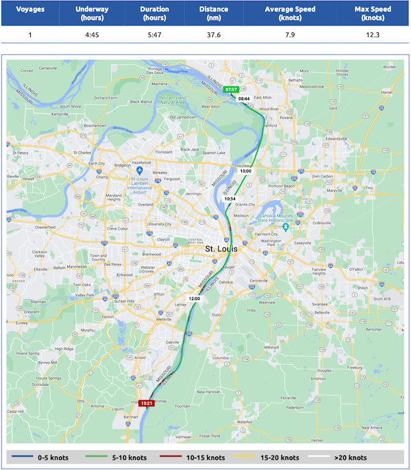
Here’s the Nebo map for November 28, 2022. Download a PDF log file with more info. Track Do It Now on Nebo.
At Hoppie’s
I topped off the tank — it only took 17 gallons — and told them I wanted to spend the night. After filling us up and taking my credit card payment, they moved the boat back to the next barge by grabbing the ropes and letting it drift back — with me at the helm with the engine running in case I needed to power out of a messy situation. Within a few minutes, we were tied up with five lines pointing upriver. One of the guys hooked up our power. Then, after giving us a menu for the local pizza place with delivery and telling us we could walk through the shack to get to land, the guys went about their business, pretty much ignoring us for the rest of the day.
I took my pups for a walk. The shore was a mess of exposed rocks and cables, mostly due to the low water situation. My dogs walked around gingerly, sniffing around and doing their business.
The restaurant in town that had been highly recommended by everyone was closed on Mondays. We were under the impression that almost everything in town was closed on Mondays. We could get an Uber but had no reason to Uber anywhere. Do It Now was stocked with food and water and everything we needed. There wasn’t much else to do but relax.
The guys were moved a derelict houseboat from one barge to another, towing it with a small fishing boat that was barely up to the task.
I took my drone out to get a few photos.
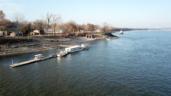
Here’s an aerial view of Hoppie’s shot with my drone. It was an interesting stop.
Later, since my Looper friends had raved about the pizza delivered to Hoppie’s, we ordered out. But we didn’t order pizza, which I think was our mistake. Alyse ordered a pasta dish — maybe Alfredo? — and I ordered a sausage calzone. To my horror, the calzone was mostly bread with a sad amount of what looked like cheese from a jar and an even sadder quantity of sausage. We later decided that the same jarred cheese had been the sauce on Alyse’s pasta. Ick.
We settled in for the night. Despite warnings about barge wake from various reviewers on Waterway Guide, it was a quiet night and I slept well.

