August 17, 2021: 41 Miles, 5 locks, and some crazy straight canal.
I woke up on the sofa in the Rotary Park Dock’s offices. It was around 5 AM and still dark outside.
I got dressed and folded up my bedding. Then I spent some time reading on my iPad. At 6 AM, I took everything and headed out to the boat, locking the building behind me. I left no trace of my overnight stay and, to this day, wonder whether they had a camera in that room.
The Annotations
I had brought along my copy of the Cruising Guide to the New York State Canal System, which I discuss briefly in a blog post about doing my homework in preparation for this trip. The reason I brought it — even though I knew Capt Paul would have his along — was that I thought I might spend some time making notes on the maps inside it. Up until this point, I hadn’t made many notes at all.
Now I decided to concentrate on those annotations as we moved forward. It’s a good thing I did, because as I write this, four days later, I can barely remember that day’s travel.
(Seriously, this is all become a blur. I think it’s the pace we’ve been keeping. At my first two stops — Croton-on-Hudson and Kingston — we spent two nights. Since then, we haven’t just been spending only one night per stop but we’ve usually been moving the next day by 7 AM.)
We continued our rotating shifts. I’m sure I drove the boat for at least two hours, but I can’t tell you which two hours it was. I can tell you — based on my annotations — that most of the canal ran either in or near the bed of the Mohawk River and that we locked up — meaning that we rose in elevation — at each lock. There were trees on both sides, sometimes a thin line of trees on the water’s edge hiding a marsh behind them and other times a lot of thickly forested woods. Near towns, such as Fort Hermimer and Mohawk, there were houses, many of which had docks on the canal/river. There were also parks, with and without boat launches.
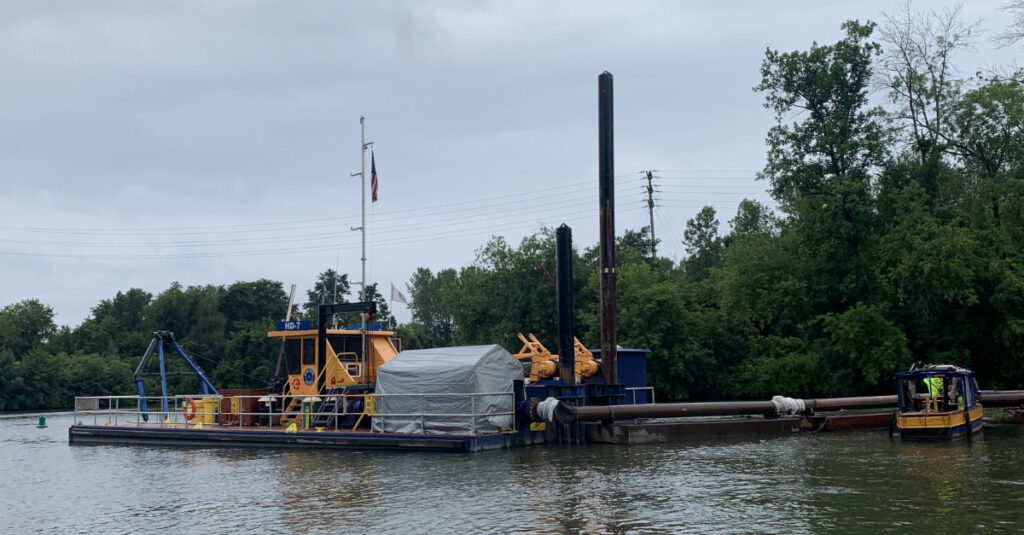
According to my notes, the Ilion Marina has a campground and there’s a dredging operation just outside the entrance to Frankfort Harbor Marina, which wasn’t visible from the canal. Frankfort is also where the Canal and Mohawk River parted for the last time; the river would wind along to our west for a while before shrinking down to a tiny stream just past Rome.

A dredging operation outside Franklin Harbor sucked mud into a pipe and spit it out on the canal bank a few hundred feet upstream.
I labeled Lock 19 the “Lurking Lock,” because it was hiding (or lurking) under a railroad trestle.
There was debris like logs in the water. At a few places, dams on the banks overflowed to put canal water into a lower stream like the Mohawk River or West Canada Creek. At another place, a temporary buoy marked where silt had built up in the canal to make the water shallower than it’s supposed to be.
We passed a lock going down from the canal to Utica Harbor, which is closed to the public.

Going down? This lock led from the Erie Canal to the Utica Harbor on the Mohawk River.
The canal went on and on and the photos you see here are the only two I took that day. I think I was feeling burned out. And it was probably raining on and off, too. I know the weather started to get rainy around this time.
Somewhere just before Guard Gate 6 at Rome, the canal got very straight for a very long distance. My note on the next page says “Crazy Straight!” I’m pretty sure I was driving at the time because I remember switching the heading on the autopilot from 300° to 299° to 300° to 299° and back and forth. And that’s it. It went on for at least 15 miles, right through lock 21.

Here are my annotations on a page of the Cruising Guide where the canal was dead straight.
Locking Down to the Lake
Lock 21 was special for another reason: it was our first time locking down. That means we entered the lock at a higher point on the canal than we exited it.
You can tell you’re going to lock down just by looking at the lock. If it’s built into the side of a hill, you’re locking up. If there’s no hill in front of you, you’re locking down.
Lock 21 and Lock 22 dropped us down a total of just over 50 feet.
The canal was still pretty straight after that, but in shorter segments. Finally, at a bend in the canal where a U.S. Coast Guard Auxiliary Station is situated and Fish Creek enters the canal, we reached Sylvan Beach on Oneida Lake, our final destination for the day. It was just after 1 PM.

Here’s the log created by Nebo for Day 8 of my time on Nano. You can track us on the Nebo boating app; just look for Nano Paul G.
At Sylvan Beach
Sylvan Beach is a kind of shore community where weekenders come to go boating and fishing on Oneida Lake, a 21-mile long, 5-mile wide lake that’s the source of the Oneida River. There are two marinas there; the first one didn’t return Capt Paul’s call until much later in the day, but the second one, Holmes Marina, which supposedly had no transient parking called back to offer us a space with power, bathrooms, and showers for $40 cash. We took it.
The space the owner gave us had been his space. He’d sold the boat and bought a patio boat that he put in the water when he used to to free up the space for another long term tenant. It was currently available so he put us in it. It was conveniently located close to the restrooms. The marina was full of other boats, but because of the weather or the day of the week — it was a Tuesday, I think — no one else was around. We paid him the $40 and he left us alone after explaining a shortcut through the woods to get into town.
Capt Paul and I walked into town. Most of the restaurants were closed — apparently, Monday and Tuesday are the “weekend” days for local workers — but the Lake House Casino was open and it had a restaurant. We had burgers overlooking a gray lake. Mine was good. Afterwards, we walked back to a convenience store, bought a few things, and headed back to Nano. We arrived just before the rain started.
Along the way, I was reintroduced to New York State mosquitos. They’d be dining on my ankles in various places for the next few days.
I think I spent the rainy afternoon catching up on blog posts. It looks like I wrote or finished my Day 6 post.
In Nano, with the air conditioning on, I was comfortable. Although I probably should have taken a shower when one was available, I convinced myself that the mosquitos would eat me alive on my way back in the rain. I would regret my decision to skip a shower that day.
We turned in after dark. It was very quiet there — that marina was probably the quietest place we’d stayed since I boarded — and I slept very well.

There is something nice about seeing handwritten notes on a map!
Agreed! I’m looking forward to consulting them the next time I come through here.