June 2-8, 2024: I travel up to Lake Champlain, spend four nights at anchor and two nights at a marina in Burlington, VT.
After spending two nights at a friend’s home in East Wallingford, VT where I was able to do my laundry and get some groceries for my continued travel, we returned to Do It Now, which was parked at New Whitehall Marina. We ate lunch up on the command bridge with the bimini top up while we waited for the owner of the marina to complete some repairs on my propane setup. When he was done, we cast off for a 3-hour round trip cruise up Lake Champlain.

Tom is one of my oldest friends. We met in the 1990s, not long after I left my corporate job to start a freelance writing and computer training career. Back in those days, we both ran computer BBS systems that were networked together using something called Fidonet. This was all before the Internet took off. Tom and Tammy married about 25 years ago; I was at their wedding with my wasband. They moved to Vermont about 20 years ago and we kept in touch.
I have to admit that the cruise wasn’t very interesting. The lake is very narrow on its southern end and it didn’t appreciably widen before I turned around. The first few miles were a narrow channel with mostly marsh on both sides. Then we got to an area where the lake cut through some rocky hillsides. It was just widening a bit with homes on one side when I turned around and took us back.
Tom and Tammy seemed to enjoy the trip. Tom liked the boat. He said it was perfect for camping on the water — which is pretty much what I do. I did get to show off full speed operations — I think I got it up to a whopping 18 knots.
After our ride, we stopped in at the tavern at the marina for a drink. The owner, Lynn, took us into a workshop to show us the work he was doing on two vintage wooden boats. It was fascinating. When the drinks were done, Tom and Tammy left. I went back to the boat to put away my laundry and get things ready for the next leg of my trip: a week on Lake Champlain.
Whitehall to Crown Point
Sunday morning started with fog on the surface of the water, a side effect of the water being warmer than the air. I made a good breakfast and took a shower. I topped off the fresh water tank.

There was fog on the water on Sunday morning.
I was in no hurry. I had a list of potential anchorages and marinas, some of which had been suggested by my friends on New Bearings. I knew I’d do an anchorage that first night out and figured it would be around Port Henry, maybe in Bulwagga Bay. So that’s where I headed Sunday morning, right after Lynn showed up, I got a pump out and fuel top off, and I settled my bill with him.

I drove from up on the command bridge. I really like being up there on a nice day.
The first 90 minutes was a repeat of the day before. New York was on my port side and Vermont was on my starboard side. It was the 17th state I’d visit with my boat on the Great Loop. (If anyone had told me years ago that I’d someday visit Vermont in a boat, I would have told them they were nuts.)
The water was calm until we got into a wider part of the lake, where a light breeze introduced a chop to the water’s surface.

It was a Sunday so as the day progressed, more and more boats came out. I got a lot of joy seeing sailboats out that were actually under sail. (Most sailboats I see are either motoring or motor sailing.) Of course, that gave me more responsibility. Sailboats under sail have right of way — technically they are the stand on vessel — over motorboats so I had to make sure my motoring along at 7 or 8 knots didn’t interfere with their sailing course, which could include sharp or sudden turns to tack into the wind. I got pretty close to a few of them, but only after I was sure no collision was possible.
I got up around Fort Ticonderoga, a rebuilt 18th century fort that played a major role in the Revolutionary War and American independence. I could see some of the buildings from the lake but there was no way to get ashore other than the fort’s private tour dock. I did see the tour boat out on the lake and wished I had better light for a photo. It’s a shame they don’t have a day dock for boaters; I would have planned my trip differently and made a stop there if they did.

The tour boat that operates from Fort Ticonderoga.
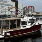
Along the way, I also caught up with and passed a catamaran that had stopped at New Whitehall Marina that morning for fuel. They had an interesting story. The owner was on board with a delivery captain and a friend. He’d bought the boat out on Long Island Sound and they had motored it through New York City and up the Hudson River. Around Catskill, NY where they’d gotten the mast stepped down for canal passage, one of the boat’s two engines had died. They had continued their journey using the dingy’s small motor as a second engine, tying the dinghy to the side of the boat with the bad engine. They’d managed to go through all the locks on the Champlain Canal like that and were continuing on to Burlington, VT.

The dinghy attached to the side of this catamaran is actually providing engine power for the boat.
I also passed a cable ferry, which was interesting. The ferry runs along a cable that’s laid down along the bottom of the lake. It lifts the cable on one side of the boat and drops it on the other. Fascinating to see but I didn’t get a photo. Sorry!
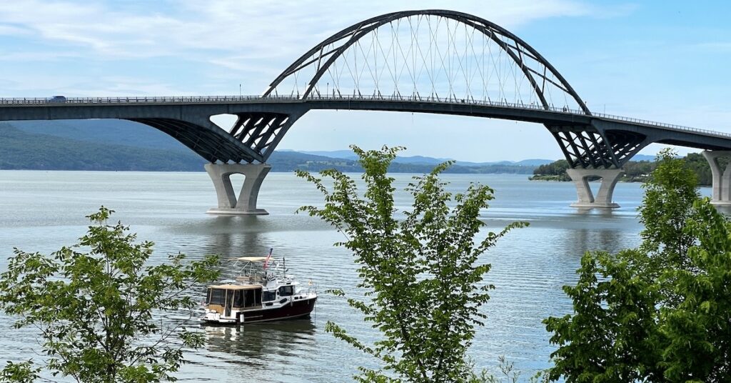
Eventually, I got to the Lake Champlain Bridge, which is actually the second bridge at this location. The first was built in 1929 but, by 2009 it was determined to be unsafe for continued use. It was demolished in 2009 and the new bridge, which looks remarkably similar, was opened in 2011. Keep in mind that this is the only bridge crossing of Lake Champlain between Whitehall, NY and this point. There is no bridge farther north until Rouses Point, which is just south of the Canadian border.
As I got closer to the bridge and the pier and monument at Crown Point, I realized that there was a nice little sheltered area that would make a good anchorage. In fact, there was already a sailboat parked there. I moved in slowly, giving the other boat plenty of space, and dropped anchor in about 8 feet of water. There was a bit of land and also a boat ramp with a dock that would make it easy to take my dogs to shore. I killed the engine and settled in for the night.
At Crown Point
First order of business was taking my pups to shore. I launched the dinghy and we all climbed aboard. I motored over to a place near where rock ledges came out into the water from the park at Crown Point. I stopped the motor and pulled it out of the water as the boat glided to shore. I tied it to a tree and got out with my pups.
We explored the area, starting with the large covered pier where folks were fishing. It wasn’t until we left the pier and walked up to the monument that I saw the “No Dogs on Pier” sign behind us. Oops.

The Champlain Lighthouse. The statues are on the other side; the light was bad to photograph them so I didn’t bother.
The monument was the Champlain Lighthouse, which included a bronze statue of three men. We walked around the lighthouse and I was surprised to find the door at the base open to a concrete flight of spiral stairs. We walked up — although now I think my dogs weren’t allowed in there either (oops) — and, near the top, I climbed the ladder to the little viewing platform that wrapped around. I took pictures and then came back down.
We kept walking. There was a campground with a few trailers parked. Some folks were having a picnic lunch. There were good views of the anchorage and bridge beyond.
Once my girls had done all their business (and I’d picked it up), we headed back to the dinghy. I rowed back to the boat — it was that close — and secured it, then went about making dinner: an excellent paleo moussaka that I really like.
We made one more trip to land before nightfall, this time to the boat ramp. I discovered that my neighbor on the sailboat also had a dog: a big golden retriever that liked to play in the water on shore.
Mother nature treated us to an excellent sunset.

Here’s a photo of the Champlain Bridge that I shot at sunset that evening. The sailboat was sharing the anchorage with me.
In the morning, after breakfast, I took my pups ashore at the boat ramp again. We hiked under the bridge and into the historic part of the park. From the Crown Point State Historic Site website:
Crown Point State Historic Site is dedicated to the preservation and interpretation of the ruins of two fortifications from the colonial wars between the British and French. Long before the American Revolution these colonial powers both laid claim to the Champlain Valley and this strategically important peninsula known as Crown Point. The French built Fort St. Frederic here between 1734 and 1737 and used it as a base for raids on British settlements in New York and New England. As a result, the British mounted various expeditions to take control of Crown Point, and in 1759 they were finally successful. They immediately began construction of new fortifications that they called “His Majesty’s Fort of Crown Point”. Enclosing over seven acres this was one of the largest built by the British in North America.
In 1775, at the outbreak of the Revolutionary War, the American colonists captured the fort and secured sorely needed cannons and heavy ordnance. Crown Point was occupied by General John Burgoyne’s army in 1777 after the American evacuation to Mount Independence and remained under British control until the end of the war. The ruins of Fort St. Frederic, “His Majesty’s Fort of Crown Point,” and surrounding lands were acquired by the State of New York in 1910.
We hiked around the ruins and my pups got a chance to run around on the grass. No one else was around — it wasn’t even 7 AM when we got there. It was a nice day, without much wind, and it was still cool. Very pleasant to walk around a deserted park with my dogs.

The ruins of Fort Frederic make a nice place for an early morning walk.
We walked back to the dinghy and then went back to the boat. I fed my pups and made a batch of granola in the oven, glad the propane issue was fixed.
Finally, at around 9 AM, I pulled up the anchor and we headed on our way north.
Crown Point to Valcour Island
I had set up cameras on the command bridge to record some video of the cruise. As part of that setup, I’d pulled out my wireless microphone with its “dead cat” wind screen and connected it to a GoPro. More than a few folks had complained about the sound in my videos and I was determined to fix it.
But I soon forgot all about the video as I got under way and realized that none of my chart plotters could get a GPS signal. At first I thought it was an outage, but as my iPhone and iPad were able to connect, I assumed it was a boat system issue. I went so far as to shut everything down mid-lake — including the connection to the battery to force a system reset — and then power everything back up. No joy. None of my chartplotters worked.
So I navigated using Aqua Map on my iPad. It was not ideal. Oddly, the autopilot’s Heading Hold feature still worked fine. So did the fuel flow information from the engine so my fuel level was properly updated. It was just the GPS.
I called Garmin and was on hold for technical support for about an hour and 15 minutes. (No, I’m not exaggerating.) The tech guy walked me through a bunch of troubleshooting steps. Nothing fixed the problem. We began thinking that maybe the internal antenna wasn’t working right and that I needed to buy an external GPS antenna for my system.
Great. A potentially costly repair to deal with in the middle of nowhere. I hung up feeling disappointed. My brain was already working on where I might be able to get the problem fixed.

We passed the Four Brothers Islands, which is a bird sanctuary managed by the Nature Conservancy, along the way. As you can see, Lake Champlain was almost mirror calm that day.

Here’s where I dropped anchor off Valcour Island. Once again, I was close enough to land to row the dinghy over when I wanted to.
But not that day. That day I was heading for Valcour Island, which looked like it had several sheltered coves to park in. I planned on anchoring in one of the smaller ones on the west side. Called Bluff Point North by Active Captain, it’s just north of the lighthouse on Bluff Point. I could anchor in less than 10 feet of water with what looked like a beach to take my pups to shore and lots of hiking trails on the island to explore.
I reached the anchorage and was a bit disappointed to find a boat on shore beside a campsite with several tents as well as a floating dock that looked as if it might be for swimming. I’d really been hoping to have the little cove to myself. But I was tired and felt done driving so I just pulled in as close to shore as I dared and dropped the anchor in about 6 feet of water. I shut everything down.
Later, when I moved everything from the command bridge down to the main cabin, I realized that I’d left the wireless microphone transmitter on. I turned it off. Then, on a whim, I turned on my chartplotter. It immediately got a GPS signal. There was nothing wrong with it. The problem had been because of interference with the wireless microphone system.
I still don’t know whether I’m more annoyed than relieved.
At Valcour Island

Here’s my dinghy parked on the beach with Do It Now anchored in the little cove behind it.
Right after arrival, I took my pups to shore. There was a nice little beach that they could run on and they did. But we also hiked over to the lighthouse. That’s when I realized that the trails were overgrown — think junglelike — with bugs and cobwebs.

The lighthouse was a stone and wood building that was completely closed up.
We made it to the lighthouse — it was less than half a mile — and walked around a bit. There wasn’t much to see other than the building and an interpretive sign. It was completely closed, although signs promised that it was open on Sundays during certain months. It was Monday.
We walked back to the dinghy and went back to the boat. I baked the second batch of granola. (My oven is small.)
It got hot in the sun with very little breeze. The coolest spot was in my sleeping cabin. So I napped.

Martini time was sunset up on the command bridge.
I made yellow curry chicken with sweet potatoes, onions, and yellow squash for dinner. I took my pups to the beach before sunset. Later, I had a drink up on the command bridge. I saw a deer drinking from the water on the far side of the cove.
We spent two nights at Valcour Island and it turned out to be a very good anchorage. It was well sheltered from the wake of boats out on the lake. My only real complaint was that on that first day a handful of day-trippers came into the cove and beached their boats and jet skis on the beach. No one stayed long. The junglelike forest didn’t make for good hiking in flip flops. The jet skiers were particularly obnoxious because they revved up to full throttle when the left, waking my boat a lot more than what was necessary.
My camping neighbors were mostly quiet. They played some music kind of loud late that first afternoon, but not for long. They didn’t do it again. I didn’t play music either. The quiet was wonderful.

The island is full of campsites and I think each one had an outhouse. It reminds me of the boat-in campsites on Lake George that I visited with my future wasband many, many years ago.
I did an early morning hike on the second day. I dressed appropriately with long sleeves, long pants, and hiking shoes. I must have brushed cobwebs out of my face 100 times. It was still cool but I sweated profusely in the humidity. We got to the other side of the spit of land where the lighthouse is, then found the first trail back toward our cove. We had to hike past the campsite — which was empty — on the way back to the boat.
I wasn’t quite hot enough to go in the water, but the water was certainly clean enough to do so.

Lily and Rosie joined me on the command bridge for my afternoon cocktail but were more concerned with what they might see back on the beach than the sunset.
I spent the rest of the afternoon relaxing and working on my blog post about arriving in New York Bay. I had an excellent Internet connection via both cell phones. (Yes, I have two cell phones on board. One is my main iPhone (13 Pro) on Verizon’s network that I use for most stuff. The other is an old iPhone 8 Plus on the Google Fi network that I got for free and use for Nebo, Anchor Pro, and flying my drone. Between the two of them I almost always have an Internet connection.)
Fewer boaters came into the cove that day, which made the afternoon more pleasant. I flew my drone. We had another nice sunset.

I flew the drone on the second evening. I’m getting pretty good at launching it from the solar panel over my aft cockpit. This shot gives you an idea of my surroundings and includes the campers and the swimming float.
I slept well for the second night in a row, but was wakened by the sound of rain that was not in the forecast. A few times, it got pretty stormy. I managed to get my girls to shore between showers and stowed the dinghy. I’d planned to move on to Burlington, VT that day anyway; I figured I may as well get an early start in case the weather got worse.
At Burlington
It was a short trip to Burlington from Valcour Island, but conditions were not good. The serene Lake Champlain I had come to know and love was gone, replaced by its angry cousin. The wind kicked up a heavy chop and the rain fell, sometimes in sheets. I crossed the lake, looking for shelter from the wind closer to the other side. I never really found it. But the rain did stop and I was able to get into the Ferry Dock Marina without getting dumped on.

Changing the oil on my Volvo Penta D4 300 engine starts with a suction pump.
It was a nice facility. I took my pups for a quick walk and checked in. Then I went back to the boat to do one of my least favorite chores: an oil change.
One of these days, I’ll do a blog post or video detailing what’s involved in changing the oil on my boat. Today is not that day. Let’s just say that it’s a time-consuming messy job that I hate doing but feel a certain amount of satisfaction in getting done.
In the meantime, I was in touch with Trish, the woman who had been part of the crew on the semi-crippled catamaran I showed a picture of earlier in this post. She wanted to meet up for late lunch and I was game. So I set up an appointment with her at the marina’s restaurant at 3:30. I had just enough time to finish the oil change, shower, and put on clean clothes before I met with her.
We had a nice lunch and chatted about all kinds of things. That’s one of the things I really like about traveling — meeting people. She gave me tips about places to go in town. I was supposed to stay just one night, but since I’d pretty much killed that day with the oil change, clean up, and lunch, I decided to stay a second night.
Back at the boat, I relaxed and worked on blog posts. It was so hot and humid out that I didn’t feel as if I’d showered at all. I went up to the command bridge for an evening drink and was treated to an amazing show of skill by the charter sailboat captains. They’d come right up to the marinas, under sail power, tacking back and forth between the slips and the breakwater to arrive at their destinations. Then their sails would drop and they’d motor the last few feet to their slips. What a show!

I watched the sailboats come in under sail power as the sun set behind them. What a great way to end the day!

Although I’m not 100% pleased with the bike basket, I do admit that it’s very sturdy.
In the morning, after feeding and walking my pups, I got out my bike and installed the new basket, which had been shipped to New Whitehall Marina. Of course, the screws were too long.
I biked over to August First, an excellent bakery that my friends on Ginny had recommended. I had a breakfast sandwich, which I ate outside, and then bought some breakfast pastries for the next day.

I highly recommend August First, which is walking distance from Ferry Dock Marina, for breakfast and/or coffee.
From there I went to City Hardware to get new screws for my bike basket. They didn’t have exactly what I wanted, but I got something that worked.
I also walked over to the City Market Onion River Co-op to pick up a few grocery items. They had a great selection of cheese and bulk goods. A little pricey, but I didn’t need to buy much.
I returned to the boat and put everything away. Then I went back out with the bike, parked near Church Street, and went for a nice walk. (Church Street is closed to bicycle and auto traffic.) I visited a bunch of shops, had a great conversation with a woman in a jewelry shop, and bought a handful of clothing items that would be better in hot weather than the t-shirts I’d been wearing. (Yes, t-shirts and jeans or shorts is my uniform. Still. At my age. Get over it.)
I had some Thai food for lunch, bought a dress (of all things), and walked back to the bike. I packed everything into the basket and secured it with a bungee cord. Then I headed back to the boat. But instead of going to the boat — I wasn’t done with my day, I think — I headed south along the bike trail. I eventually turned east and found myself at Lake Champlain Chocolates, where I went in (of course), bought chocolate (of course), and had ice cream (of course).
Then I remembered that I needed a Canadian courtesy flag and decided to bike over to the West Marine shop that was inexplicably not located near the harbor. That required some uphill riding that my ebike with me on board was not prepared to handle. Think San Francisco’s steepest hills. So I walked the bike up. No worries. Except my cell phone, which I relied upon for navigation, was nearly dead.

This radar image gives you an idea of how much rain we had that evening.
I got to West Marine, had a nice long chat with the woman who worked there, bought the flag with some mounting do-dads and a towel, and got directions back into town. It was all downhill. Literally. I think I did the 3 miles in about 10 minutes on my bike. I was passing cars. I went back to the boat with my purchases, put the bike and my phone on chargers, walked my pups, and settled down for a good rest.
Weather moved in before sunset. Clouds and wind and rain. There was no show that evening.
I went to sleep at 9:30 in a rocking boat with rain pounding on my decks and roof.
In the morning, the weather had cleared up a bit, but it was still overcast and not very nice. I fed and walked my pups, then went to the bathhouse with my laundry. I showered, put on clean clothes, and loaded all of my dirty clothes into one of the two free washers. Free washers and driers is a rare treat, but there’s usually a catch. The catch here was that the washer I’d picked didn’t spin up fast enough to get the water out of the clothes. That meant moving all of the soaking wet clothes into the other washer and figuring out how to skip ahead to the spin cycle. By some miracle, I got it to work. Then into the dryer. Then folding and back to the boat to stow later.
It was 10:40 AM before I was ready to leave.
Burlington to Vergennes
While I was waiting for laundry, I’d met a family with three kids who arrived in a motor cat and parked next to me. We’d chatted a bit and they’d told me they’d spent the previous night at Vergennes, VT, a small town off the lake that featured a free dock by a waterfall. They pretty much raved about the place.

Radar showed a thunderstorm up ahead, crossing my path.
I’d planned to head back down lake and although I didn’t have a firm destination in mind, figured I could always stay at or near Crown Point again. But after looking at Vergennes on Aqua Map, I decided to give it a try. So I cast off and headed out with that as my destination.
The weather was not good. Thunderstorms were forecasted and I could see them cropping up on radar, moving mostly east. The lake was choppy, but not terrible. I knew that it would get worse in a storm, but I also knew that the farther south I got before that happened, the more sheltered I’d be. And it was pretty obvious that Vergennes would be extremely sheltered in its location seven miles up Otter Creek.

I could see the first thunderstorm ahead in the distance as I drove down the lake.
The first thunderstorm passed west to east in front of me as I headed south and didn’t affect me at all.
I found the turn for Otter Creek and, minding the warnings on Aqua Map about shoaling at the mouth of Otter Creek, I headed into the channel slowly. It was very narrow and my shallow water alert, which is set for 8 feet, went off. It got as shallow as maybe 5 feet before it deepened up again. I followed Otter Creek, an extremely narrow, winding channel, as it wound its way mostly east through mostly forest. At many points, it reminded me of cruising through the swamps on the St Johns River in Florida. If I’d seen an alligator, I wouldn’t have been surprised — at least not at first. I kept my speed down to about 6 knots and slowed down even more when I approached boat docks and what passed as marinas. My boat was larger than any boat I passed. That made me wonder about the motor cat, which was a hell of a lot bigger than my boat, going this way. What had people on shore thought?

Otter Creek was narrow and winding.
The second thunderstorm hit as I was steering my way up the creek. It was fierce, with high wind and heavy rain, thunder and lightning. But the water in the creek remained calm, completely sheltered by the trees on either side. My windshield wipers worked overtime, but there was no challenge to the drive.
The rain stopped just as we arrived at a basin with a dock wall. The waterfalls were beyond. They were not anything like I expected. They were a combination of manmade elements like dams and buildings that probably harnessed the water power at one time and huge rocks. The water cascaded loudly over all of it, creating a soothing white noise. I brought the boat around and managed to dock with my stern against the current so we could get on and off on the starboard side. Although I didn’t have trouble keeping the boat against the wall, it definitely wanted to move forward with the current. It took a bit of wrangling with the lines to secure it.

Here’s Do It Now, parked at the wall in Vergennes. The basin also offers an anchorage and its easy enough to dinghy to shore.
Once the boat was secure and everything was turned off, I let my pups off to run in the small park there. A while later, I had them on leashes and we were walking up into town.
At Vergennes

The library at Vergennes.
Vergennes was a cute town with a handful of shops and restaurants, a grand library building, and a nice shady park. We walked down the park side of the street, crossed over, and then walked down the side with the shops and restaurants. There was an unusually high proportion of used item consignment shops, including one we used to refer to in Arizona as “dead people’s stuff” shops. You know what I’m talking about: the kind of shop where you try to sell your late grandmother’s stuff. Tons of china and crystal and knickknacks with a smattering of furniture and table linens.
I was hungry. The one restaurant the motor cat family had recommended to me, Black Sheep, was closed. I wound up at a pizza place where I got a calzone. Amazingly, they let me bring my dogs into the restaurant. I didn’t even ask — they just told me I could. So I ate half a calzone with my pups at my feet, staying out of the hot, humid air as long as I could. I got a to-go box for the rest and headed back out.

I shot this photo of the falls as we walked down the path from the bridge.
I walked past the town’s gas station and convenience story and crossed the bridge over the dam and falls. There didn’t seem to be anything worth walking to farther up, especially with another storm brewing to the west. So we walked back down the other side of the bridge and found a pathway with stairs that followed the creek alongside the falls. It turned out to be a shortcut back to the boat. I let my pups run a little more on the way back.

Another shot of the falls from my boat. I think the real star of this shot is the clouds to the south. It was the kind of day where convective activity keeps thunderstorms building and moving across the landscape. This isn’t the storm that hit us minutes later; the storm that hit us was already just to our east.
We got back to the boat just as the third thunderstorm hit. This one was very intense. Again, we were well sheltered and tied securely to the wall, so I had no worries about our safety. But the rain came down hard and this time it included pea-sized hail. Thunder roared overhead.
And no, my pups weren’t bothered. They aren’t afraid of thunder or other loud noises; they take their cues from me. If I don’t react, they don’t react.
We stayed inside the main cabin. While my aft deck is covered, it does not stay dry in the rain. But I had both back doors wide open to let in the cooler air since I couldn’t open my side windows or upper hatches. It was refreshing, since the storm brought in a lot of cold air. It was difficult to believe I’d been sweating my ass off on the walk back to the boat only a short time before.
I spent the rest of the afternoon finishing up the writing part of my Hudson River blog post. I still needed to insert the images.
I had the rest of the calzone for dinner. It was after 10 PM when I finally went to bed. The rain had stopped and the sound of the waterfalls was the only sound.
Vergennes to Whitehall
I did not sleep well. I was up in the middle of the night for about two hours. I fell back to sleep, then woke after 6:30 AM, which is late for me. I’d been planning to leave by 6 AM — I needed to get all the way down to Whitehall, more than 50 miles south, by 3:30 PM for a late lunch date — but I was unable to cast off until 7:10.
Of course, the first 90 minutes was spent on Otter Creek, puttering along at 5 to 7 knots. I tried to follow my track in back out, but my autopilot had reduced the number of track points and wasn’t following the track as closely as it needed to. So that meant manually steering all those curves again. (And yes, I know I shouldn’t complain, but it is exhausting sometimes.)
I did try to record a hyperlapse of the trip using one of my GoPros, but the damn thing did not keep a consistent speed in the final video. So the video it created is pretty much unusable.
Once out on the lake, I got the boat up to its fast cruise speed at 3000 RPM. That got me about 14 knots. I kept up that speed unless I was passing another boat or marina. I took some photos, but not many. It was all about getting there on time.

I snapped this photo of the pier and lighthouse on Crown Point as I passed it southbound.
For the record, I don’t like cruising to a schedule at all. I’m sure I’ve said that elsewhere in this blog. When you focus on a destination and time for arrival, you miss opportunities to explore and see other things. Like Vergennes. I wasn’t on a schedule the day before so I’d been able to make that little side trip. In hindsight, it was probably a dumb idea because it added miles for that day’s trip. But I’m still glad I went because I got to see it for myself. How many other things do I miss along the way? I know I could spend a whole summer on Lake Champlain and not see something new every time I repositioned the boat.

I do a lot of standing when I drive the boat. This is why.
I got down to Whitehall at about 12:30 PM, which was excellent time. I had to stop at the Marina to take on some fuel and pick up my mail, which had been forwarded by my housesitter. Lynn, the owner, wasn’t around and the other guy who works with him could not find my mail. But I took on 40 gallons of fuel; there was much cheaper fuel down the canal and I figured I’d top off there. I wasn’t staying at the marina because, frankly, I didn’t need to. There was a free wall on the other side of the lock and that’s where my friends would be.

Paul got this excellent shot of Do It Now coming out of Lock 12 at Whitehall.
I was just pulling away from the dock and steering toward the open lock door when Lynn came out and told me he had my mail. I told him I’d walk back later to get it. Then I slipped into the lock and held the boat in place while the gates behind me closed. The water level rose. My friend, Capt Paul, appeared at the top of the lock with his current crewmember and waved.
I came out of the lock and steered to an open spot on the wall south of the three other boats already parked there. My spot didn’t have access to power, but I didn’t need it. I tied up with the assistance of another boater. Then I was walking my dogs and greeting Paul and Joe and inviting a stranger to join us for lunch.
But that’s another story.

Fantastic write up of an interesting part of your trip. I really do like/admire your writing style and skills.
Keep it coming…
Thanks so much, John. I really do appreciate the encouragement. I’m so far behind on my trip narrative, but getting comments like yours motivates me to keep trying to catch up. Please do share links with anyone you think might be interested.
I’m actually working on the next post now. Weather is terrible where I am and I have no desire to get off the boat! May as well be productive.