Got a relatively shallow draft boat? You can avoid the wait for a weather window to cruise up the Jersey coast by taking the New Jersey Intracoastal Waterway. Here’s how.
May 18, 2024 was an unpleasant day for me on the Great Loop. Not a horrible day; just unpleasant. After waiting 5 days in Cape May for a weather window so we could travel up the coast of New Jersey, I departed, at dawn, with two larger, slower trawlers for an “outside” cruise from Cape May to Atlantic City.
We checked all kinds of forecasts. We’d been checking them all week. We pretty much agreed that Saturday was the day to go. Sure, waves were forecasted at three feet, but the period was 6-8 seconds (depending on which forecast you believed) and our boats could handle that.
And they could. But my dogs sure couldn’t. Rosie puked two times and Lily puked four times. Cleaning up their puke made me sick enough to put on my Sea Bands and take a dose of Pepto-Bismol every hour. (I did not puke but I felt like crap.)
I didn’t stick around with the slower boats to prolong our misery. I pushed the throttle forward and cruised at 10 to 14 knots, covering the distance in about three hours. I arrived at our agreed-upon overnight spot at about 9 AM. I fed my dogs (for a second time that day; lesson learned) and walked them. I made myself a nice Taylor Ham and egg breakfast sandwich. (When in New Jersey….) And I tried to shake the crappy feeling that had grown on me throughout the morning.
The other two boats arrived nearly two hours later. Another boat joined us a while after that. Although we all agreed that it was a miserable experience, the folks in the other three boats were ready to do it again the next morning, this time cruising from Atlantic City all the way up to Coney Island.
I was not. I was going to take the New Jersey Intracoastal Waterway. And I did.
What You Need to Succeed
Bob423 doesn’t have a track for this part of the Great Loop, but I made my own. If you want to follow it, you can download it here. Please remember that I take no responsibility at all for your use of this information. The Captain of a boat is ultimately responsible for the safety of its operation.
Spoiler alert: I made it. I covered 58.3 nautical miles, from Atlantic City to Point Pleasant Beach on Manasquan Inlet, in about 6 hours. I started the day slow, cruising at around 8-9 knots until I hit the choppy, rather crowded water of Barnegat Bay. Then I said, “screw this,” and pushed the throttle forward.
I succeeded because I had a few things you really need to succeed and I used them:
- A shallow-draft boat. My Ranger Tug has a 2 1/2 foot draft. While I think you can do the NJ ICW from Atlantic City to Point Pleasant Beach in a boat with a draft up to 4 feet, I wouldn’t recommend any deeper draft. Sorry.
- The right tide. I left just after high tide in Atlantic City. By some miracle, the tide stayed pretty high at stations all the way up my path — until I got to Point Pleasant, which was at low tide when I arrived. It was almost as if I were chasing the high tide. If the tide is not with you — and do make a practice of checking the tides at every station along your way as you reach them, you should consider taking a break until the tide comes back. I would not do this route with a tide lower than halfway between high and low. To put that in numbers, maybe a tide of at least 2-3 feet?


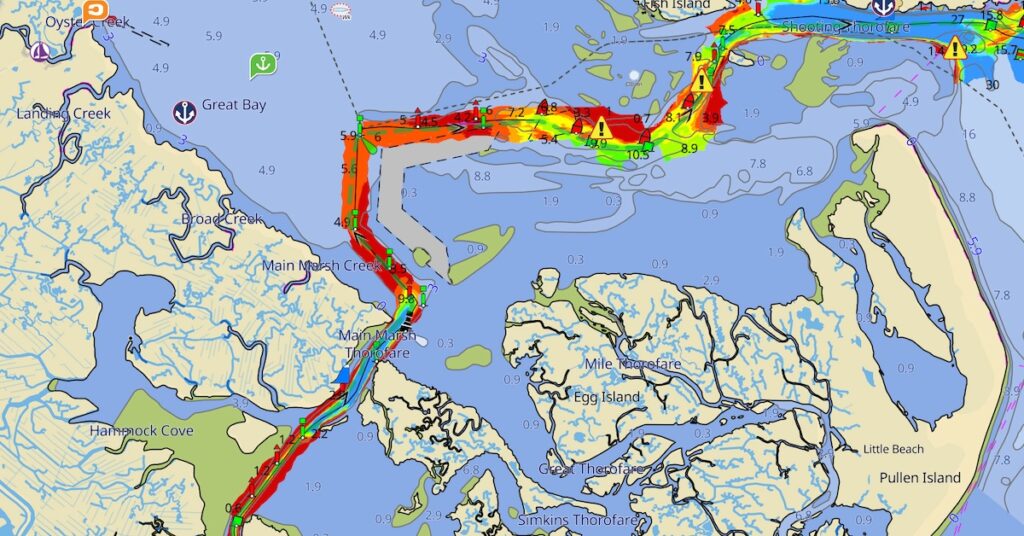
I use the Tides app on iOS to view tide stations along my path of travel. - Aqua Map with the Master subscription and USACE Surveys turned on. Don’t be cheap. Buy it already! Having the shallow areas shaded right on a moving chart image rocks. It’s also the main tool you need to thread your way through skinny water.

Here’s what I saw on AquaMap while navigating a narrow channel under a bridge and beyond.
With the right tools, navigation up this tricky waterway is exhausting but easy.
- Plan your departure time to follow the tides north.
- In skinny water, consult the soundings in Aqua Map to ensure that your boat is in the deepest part of the channel.
- Slow down when things get shallow. (A soft grounding is always better than a hard one.)
- Consult the depth shown on your chartplotter to verify that you’re keeping your boat in deep enough water.
A Note about the Fishermen
You may encounter small boats in the channel with occupants engaged in fishing. They are often in the areas with the narrowest navigable channel and shallowest water. Do not give them wide berth if you can’t. Pass them as closely as you need to. They should not be there.
As pointed out by fellow “6-Pack” Captain Jason Kopp, the Code of Federal Regulations, Title 33 § 83.09 is very clear on this:
(b) A vessel of less than 20 meters in length or a sailing vessel shall not impede the passage of a vessel that can safely navigate only within a narrow channel or fairway.
(c) A vessel engaged in fishing shall not impede the passage of any other vessel navigating within a narrow channel or fairway.

My track along the NJ ICW.
I saw so many boats doing this on Sunday that I started to think they were doing it on purpose to drive larger boats into the shallows for a good laugh. It didn’t work with me. I passed some boats as closely as 10 feet — I really had no other option — and didn’t even bother slowing down. My actions were not unsafe and I’m sure my boat’s wake sent them a message.
And if you think you can get these guys to move, think again. I encountered the same kind of local yahoo attitude in Florida a few months ago and they laughed when I told them they were blocking the channel.
How It Went
It was a long, exhausting day. I had to pay attention all day long and, if you follow my track, you’ll see that I strayed once or twice. It would be easier with two reliable captains on board. Or maybe breaking the run into two days instead of one. I’d honestly like to do it again with a lot of stops along the way to take in those Jersey Shore towns.
The water was mostly calm, although it did get very choppy in Barnegat Bay, which is also where I picked up speed. (Water depth is not an issue there if you stay in the channel.) I never saw less than 5 feet of depth, but remember that I was traveling near high tide most of the time.
One Final Note
My experience is based on the part of the NJ ICW north of Atlantic City. There’s another part between Cape May and Atlantic City and I did not try that. I was told that it was shallower than the upper part.
But everything I said here about what you need should apply to that part. Just don’t complain to me if you have a problem.


Great info and thanks for posting your track! I think many loopers will appreciate having a track to follow through this section. Also great to know that there is enough draft for a boat as big as mine 😅. Although I certainly hope to get a smaller boat with better protected running gear before I ever make that journey.
I have a sailing boat with an air draft of 60 ft. Did you go under the bridge from that AC inlet?
I’m not sure which bridge you’re referring to. I went under all of the bridges along the way and I honestly can’t remember if I needed any of them to open for my boat, which has just a 14 foot air draft.