I put the planned overnight stops into a navigation app to get a general idea of the route.
When Capt Paul was interviewing crew members for his trip from Maine to Chicago by way of the Hudson River, Erie Canal, and Great Lakes, he sent each of us a PDF of a spreadsheet that he had created that listed the days of the journey, the expected stopping point each night, the distance between points, and expected dates of arrival and departure. I had taken a look at the list and had even tried once or twice to plot the route, but it wasn’t until today that I sat down and entered each planned stop as a waypoint in a navigation app.
What changed? Well, I tried a different, more user-friendly marine navigation app, Aqua Map.
A Tale of Two Marine Navigation Apps

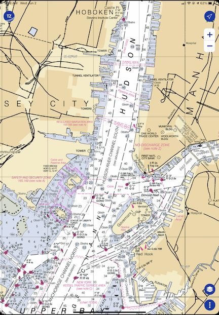
Here’s New York Harbor as it appears in TZ iBoat. This is a raster (“r” = “real” is my way to remember it) chart. TZ iBoat will automatically switch to the view magnification that’s appropriate for the scale I’ve zoomed to.
Years ago, when I did the Learn to Navigate the Inside Passage cruise with Northwest Navigation, I looked for (and found) an app that would run on my iPad and display our position on real nautical charts. That app was TZ iBoat. I chose it because it (1) enabled me to download charts so I didn’t need an active Internet connection and (2) it supported raster charts, which are basically scanned and location encoded versions of traditional printed NOAA (or, in the case of that trip, Canadian) charts. I wanted raster charts because I wanted something that looked like the paper I’d need to consult when actually cruising. Call me old fashioned, but I’m the same way with aeronautical navigation apps like Foreflight — I always consult the sectional chart version because that’s what I’m used to.
TZ iBoat wasn’t terribly expensive. The app was free but I’d need an annual subscription to get the charts. That’s showing as $19.99 today on the App store but I’m pretty sure I paid more. I’m thinking $35. Still a lot cheaper and easier than buying printed charts.
When this Great Loop trip came up, I renewed my subscription for USA coverage. I already knew the software pretty well, so it would be easy enough to use it on this trip.

Aqua Map’s view of New York Harbor at roughly the same magnification. Because this is a vector chart, the more I zoom in, the more details are displayed.
But then Capt Paul told me about Aqua Map. I downloaded it to give it a try. I immediately realized that it had some major benefits over TZ Boat: it could display data overlays from other sources, including Waterway Guide. So in addition to charts, it would give me data about marinas, anchorages, locks, and other facilities that either aren’t included on charts or have limited information on charts. The app was free; a subscription for the US and Canada, including charted lakes, rivers, and canals, was $14.99. I subscribed and linked it with my Waterway Guide subscription. (This, I’m pretty sure, makes it unnecessary for me to subscribe to the digital version of Waterway Guide in that app.)
The only drawback to Aqua Map: it uses vector charts instead of the raster charts I prefer.
But is that really a drawback? Maybe I just need to face it: vector charts, with their customizable display layers, are probably the future of navigation, whether it’s marine or aviation. Maybe it’s time for me to move into the 21st century after all.
Of course, I’ll have both with me on the trip. My new iPad has plenty of room for both of them and the downloaded charts I’ll need along the way.
Plotting the Route
There were two ways I could plot out the planned route:
- Create waypoints for each stop along the way.
- Create a route with connected waypoints for each stop along the way.
I decided to just create the waypoints. I wasn’t going to steer the boat and, even if I did need a route laid out between obstacles, I could always create it on the day of the trip. All this data could easily be stored in the app. For now, all I really wanted to know was the general planned route and I figured that would show up well enough once the waypoints had been entered.
I did that this morning while I had my coffee and breakfast. It took quite a while. There were 51 overnight stops on the plan — some planned for more than one night — and they had to be located and created individually. I quickly learned to use Aqua Map’s search feature to find one point after another and create the waypoint. I named them with the 4-digit planned date (which I already knew was no longer accurate because we planned a later departure from New York) and the stop name. So the first waypoint I created was 0805 Liberty Landing for August 5 Liberty Landing Marina.
I only had one problem and that was when putting in the waypoints for Liverpool and Onodaga (in New York on the Canal). It seemed to me that they were the same place; I’m still waiting for Capt Paul to get back to me on my query.
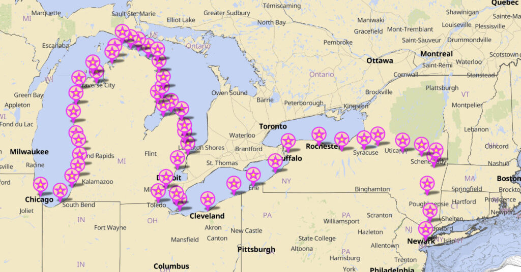
Once I zoomed out, the route became clear. While it looks like we’re boating across dry land as we cross New York, it also clearly shows which side of each of the Great Lakes we’ll be cruising along and the fact that points seem closer together on the Lakes than in the Canal.

Here’s the big picture look at our original planned route.
Of course, Capt Paul and his crew will be doing more than this. He’s starting in Portland, ME and finishing up in Stuart, FL. What I did here represents a fraction of his cruise. But since I’m not going to be on board for anything beyond this, I didn’t bother plotting it.
Keep in mind that this is the general plan — a starting point for knowing where we’re going and how long it will take. I seriously doubt we’ll follow this to the letter. Capt Paul is already making changes to overnight stops along the way so we can enjoy a dinner at the Culinary Institute of America in Hyde Park after leaving New York City. I’ll be making an updated version of the route as we travel.
I’m also starting to consider turning the breadcrumbs subscription back on for my ancient Spot Messenger — if I can find it — so friends and family members can track me in real time. It might be worth it if I can get a pay-as-you-go monthly subscription and buy those lithium batteries it sucks down in bulk.


