Tracks for the places I go that most other folks don’t.
(updated 10-March-2023)
After a minor grounding incident in Florida in water charted to be 12 feet deep, I have embraced the Bob423 tracks — as I’m sure most ICW cruisers have. If you haven’t, you should — or you will after your first grounding.
I’m also not, however, one of those cruisers who sticks to the ICW. I like to get off the beaten path (so to speak) and visit marinas and sometimes anchorages that are off the ICW, up a tributary river.

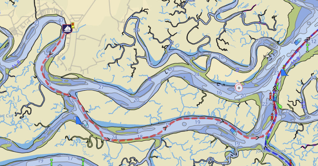
Here’s a photo of my chartplotter screen while following my track in to get back out of Halfmoon Marina. Note the depth compared to what’s in the chartplotter image.
I recently did this to spend two nights at the peaceful (but somewhat buggy) Halfmoon Marina in Midway, GA. And although my chart led me to believe that the best route was via the Timmons River, Kevin at the marina advised me that I must take the North Newport River and follow the markers he’d set up on land. He explained how to follow them and told me that if I thought I was too close to land, I was probably just where I needed to be. I trusted him and his markers — local knowledge, folks! — and put my boat in places where my Garmin chartplotter and Aqua Map, both with up-to-date maps, told me I should be scraping bottom. Instead, the closer to land I got, the deeper it got. And I went in on a 1-foot ebbing tide!
Bob423 has tracks for what he calls “side trips.” These go off the ICW to various anchorages or marinas. They show up in a different color when you import them into your chartplotter so you don’t follow them by mistake. You can find a link to them at #6 on the Bob423 Long Tracks page. That page is also where you’ll find the latest versions of his other tracks. And links to more Bob423 stuff.
Anyway I wanted to share the tracks I made while cruising to these off-ICW destinations. These are GPX files and I’ll leave it to you to figure out how to download them and get them into your chartplotter or navigation app.
Please understand that I take absolutely no responsibility for your use of these tracks. Use them at your own risk. Yes, my boat has only a 2.5 foot draft, but I did not get into any shallow water enroute. Still, it is your responsibility to monitor for water depth and obstacles while following any track from any source. Conditions, including shoaling, change every day. Although these tracks were valid on the day noted, they may be invalid after the next storm. Who can say? If you find any problems with any tracks listed here, please comment below to share what you know. If you also make your tracks available for free download, you can link to them in the comments, too.
Here’s the list as of March 10, 2023. I’ll update this when I add more.
Marinas in Georgia
In March 2023, I visited two off the beaten track marinas in Georgia:
- Two-Way Fish Camp in Brunswick. I went for the $3.99/gallon diesel fuel and spent the night. There’s a nice little restaurant there but not much else. It’s about 5 miles off the ICW. Track (and fuel price) valid as of March 6, 2023. Download track.
- Halfmoon Marina in Midway. I went for a relatively inexpensive overnight stay — check pricing in advance because it did not match Waterway Guide — and good service in a peaceful setting. Again, there wasn’t much else. The owner, Kevin, will loan you his car for quick trips into town for groceries, etc. Marina is about 6 miles off the ICW. Track valid as of March 9, 2023. Download Track.
Note that I tend to seek out low-cost marinas and quiet anchorages. I don’t need a lot of outside stimulus like shops and restaurants; I prepare most of my meals on board. You can read about all of the marinas and anchorages I list here, including my reviews, in Waterway Guide.

This is great information. We saw Ulich in Tarpon Springs. I am planning to visit half moon. How do I download this file ? Any advise ? Thanks great information
You’re welcome!
You should just be able to click it to download it. How you get it into your navigation app of choice depends on that app. Check the documentation for the app to learn how to import GPX files. That’s a standard format that all GPSes can understand.
You have inspired me. Can you tell me the best way to find someone who may want to take on a crew member. I have a little experience with boating but would love to get my sea legs back.
You should try FindACrew.net.
When I get my Captain’s license, I will be offering 1 and 2 week cruises with me on my boat, which will include instructions on driving a boat, using a chartplotter for planning, docking, and anchoring. When the time comes I’ll will begin advertising it here. The cost for one will be nominal; basically just contributing to the cost of the cruise.