I remember every single cruise day with a detailed log entry. You can, too.
Let’s face it there are a lot of days on the water when you’re cruising 6,000+ miles. Every day is a little different and, over time, they might start to blend into each other and become indistinguishable.
That is a likely outcome if you don’t keep a detailed cruise log.
If you’re doing the Great Loop, do you really want your memories of such a long, potentially life-changing journey to be a blur? I don’t.
I also started keeping a regular daily journal on January 1 of this year. I bought a 365-page bound book with lined pages and have been faithfully summarizing my days in it. These pages also help jog my memory when writing up my travels for this blog — they are in addition to any cruise-related entries I make elsewhere.
If you’re not the captain and don’t have any boat logging responsibilities, consider doing this on paper or a computer to help remember your trip in years to come.
Or blog it. Lots of folks do that, too.
In addition to the blog posts I’m trying to keep in the Travelogue portion of this blog, I keep a detailed log book of every cruise day. In fact, that log book is often what prompts my memory for a blog post when I’m writing about it days (or weeks!) after it happened.
The Benefits of Logging
The captain of the boat should be keeping a log of when and where the boat travels. Dates, times, places, and engine hours are a bare minimum. Regular maintenance like oil and filter changes and fuel and oil added are helpful information, too. Consistent entries can help you keep track of your vessel’s use and maintenance and be extremely valuable to a new owner when you sell.
(The previous owner of my boat did not log anything, despite owning the boat for three years. Of course, he only put 30 hours on the engine in that time so I’m not concerned about missing something.)

I looked at a lot of log books before finally buying the Boat Galley’s Ship’s Log.
There are logbooks you can buy to track your boat’s activity. Most are pretty basic and designed primarily as boat documentation. Others include space for more detailed information over time. The Boat Galley’s Ship’s Log is good one and is the one I bought when I got my boat. It has forms to fill out for lots of information you really ought to keep handy on your boat. I like that it’s spiral bound and easy to keep open to a specific page.
I Wanted More
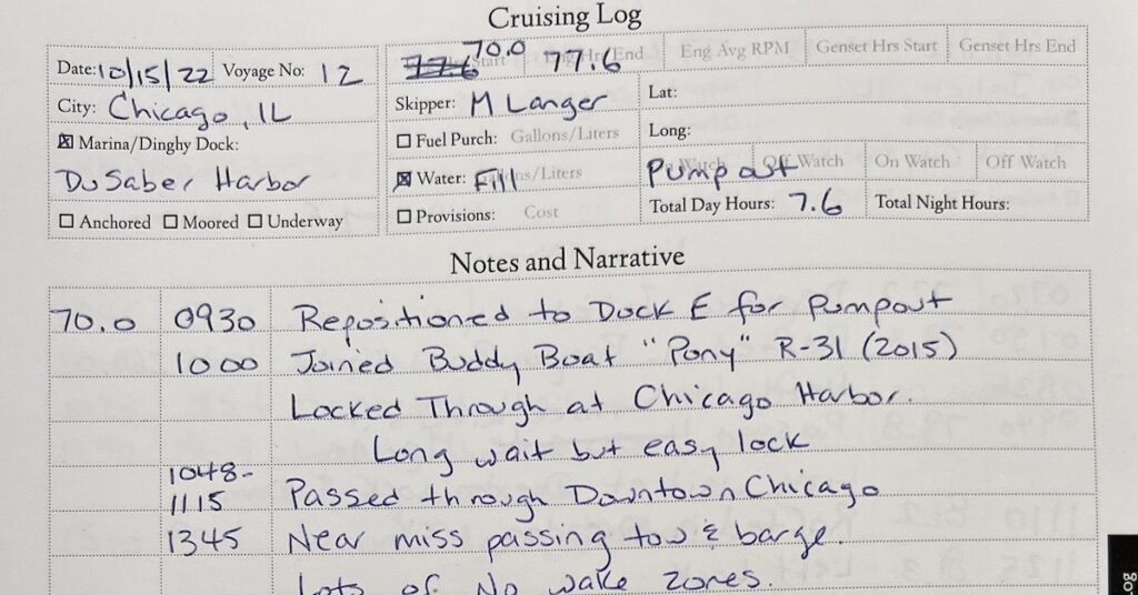
The real selling point of the Boat Galley’s book for me was the Cruising Log pages where I could put details about each specific cruise day. There were form fields for the date, voyage number, engine hours, city, marina/dock, skipper, and other fields I never used. (I only have one engine, I don’t have a generator, I don’t do watch shifts, etc.) There was also a generous space for “notes and narrative” where I could make notes about the cruise throughout the day. (If you’ve been reading this blog since my Great Loop trip with Capt Paul, you may recall that I had custom log books printed to record a narrative for each day.) It was this space that interested me most. I kept copious notes on most days.
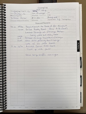
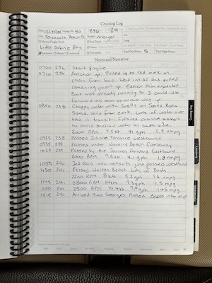
Two sample pages from my Boat Galley cruising log, including the one from my first day on the Loop in Chicago. As you can see, the amount of detail can vary greatly. On some days, I log power levels to get an idea of performance. On other days, I note landmarks or points of interest.
I kept a separate page for each cruising day — until I ran out of pages. I guess most folks don’t cruise 4 to 5 days a week for weeks on end? There were only enough pages for 58 cruising days in that book.
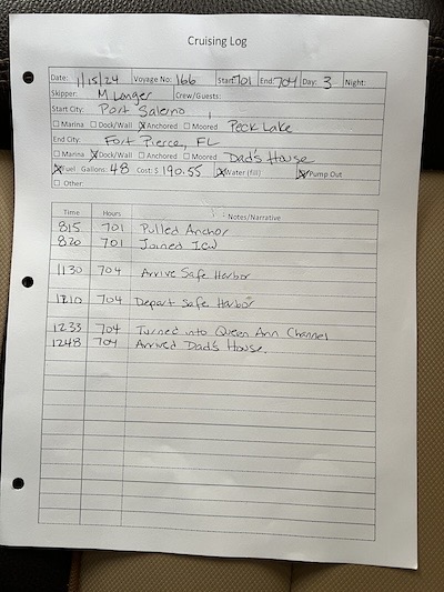
Another example of an actual cruising log entry page — this one from the day I arrived at my dad’s dock in Fort Pierce, FL. I stopped for fuel and a pump out along the way.
I saw the end of the pages coming and prepared in advance by creating my own logbook pages. I have a laptop with me and I’m pretty handy with it. I made a customized version of the Boat Galley’s Cruising Log pages, and had them printed, double-sided to save space, at a FedEx print shop. Back at the boat, I punched holes in them — we all have 3-hole punches on our boats, right? — and put them in a looseleaf notebook. Actually, I put some of them on a clipboard first so I could write on them while under way and then stored them in a notebook every two cruising days. I just finished voyage #166 — I started the Great Loop on voyage #12 — so, as you can imagine, I have a lot of pages stored.
Another Improvement
Over time, I grew dissatisfied with my format. There weren’t enough spaces to record the info I wanted to record. Some of the information was repetitive. So I modified the form again and had 50 double-sided copies of the new form printed. I pulled out the leftover old forms and stowed them in case I run out of the new ones. I can’t wait to start using them.
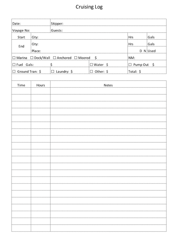
This is the newest version of my log form. I added fields to help me track fuel usage and other travel-related expenses, such as ground transportation and laundry. I can use it as a single source of information for entering data into the spreadsheet I’ve been keeping to track my trip mileage and expenses.
If you’d like to download this form for your own use, you can find it here.
Your Solution
These are my evolving solutions. They might not be right for you.
Do you log your cruising days? If so, what do you use? What do you record? Please take a moment to share your thoughts about this. I’m sure other readers can learn from what you do, too.
I’m curious about the reliability of Navionics…in particular, their chart plotter……what’s your experience?
We’re doing the Downeast Loop this summer on our Ranger R31 CB. Being a 2014 vintage, Garmin no longer sells charts for our screens so I plan on using Navionics for navigation and the stock screens for engine info, radar, etc…
I don’t use Navionics, mostly because I had a bad experience following someone else who did. The route Navionics gave him sent us through shallow water and under low bridges. You can read about it here. Other folks swear by Navionics.
I use Aqua Map on my iPad for pre-trip planning and rely on my Garmin GPSMap 7612 chartplotters to TRY to keep me out of trouble enroute. I’m very surprised you can’t get chart updates; have you contacted Garmin directly with your chartplotter model to make sure? It seems to me that Garmin wouldn’t pass up an opportunity get its hardware owners to buy updates.
I’ll be talking about trip planning using Aqua Map and other tools in the series I started this week. New posts in that series will appear every Sunday for next next month or so.
I have not contacted Garmin directly….I was told by my friend at the marina store that they no longer supported my units….I think they are FAR more interested in selling hardware than data cards 🙁
For Garmin, start here: https://www.garmin.com/en-US/p/802644/pn/010-13177-00
There’s a link at the bottom of that page where you can check for compatibility.
My chartplotters are 5 years old now (circa 2018) and I had a Garmin guy update the firmware when I first got the boat in September 2022. He told me I couldn’t update my charts, but offered to sell me three brand new chartplotters. He was wrong about the updates. I can update them for $99 — ideally twice a year when the new charts are released.
Also, Garmin technical support is VERY helpful — if you don’t mind waiting for them to pick up the phone.
Just off the phone with Garmin and….they no longer support cartography on the 7200 series.
Well, that’s disappointing to be sure. I honestly don’t know what I’d do without my chartplotter/autopilot setup. It really reduces my workload at the helm. Neither Navionics nor Aqua Map can work with an autopilot.
My current Garmins are working just fine, autopilot and chartplotter no problem…just outdated charts and Navionics/ Aqua Map will provide that for us.
You should be fine, then.
Does Aquamap have an automatic route planner or is it all manual? On Navionic, I just tap and hold on my starting point, then tap and hold on my destination and the app creates a route. I’m not seeing that on Aquamap.
It’s the automatic feature that got the boat I followed (and me) in trouble. I would not rely on it unless you check every inch of the route it suggests. The equivalent feature on my Garmin chartplotters are equally unreliable. Aqua Map does not auto route, but it does make it very easy to create a route with simple tapping — much easier than my Garmin units.
First, let me say THANK YOU for sharing your time and gained wisdom. My wife has been reading your blog and learned so so much….plus allaying some of her fears around our upcoming 2300 mile trip. That said…I’ll use all three…the Garmin in the cockpit and helm (for data, AIS and radar), as well as Navionics and Aqua Maps. While I do love the auto routing function on Navionics, I too have seen it try to put us aground and have learned to take it’s routes with a grain of salt…