Here’s why you should and how you can use these proven tracks to navigate through the shifting shoals of the Atlantic Intracoastal Waterway.
In February 2023, about an hour after low tide, my 2 1/2 foot draft Ranger Tug briefly grounded on a sandy shoal in water charted at 13 feet.
The Wake Up Call
I was cruising northbound on the ICW just south of Fernandina Beach, FL, using the frequently adjusted heading hold feature of my autopilot to stay somewhat near the recommended track indicated on my Garmin GPSMap 7612 chartplotter. I was wondering why a sailboat off my port bow had decided to anchor so close to — or maybe in? — the marked channel. That’s when the shallow water alarm went off. I have it set for 5 feet, but there’s another 3 feet of “wiggle room” in there so the depth was probably about 8 feet. I reached instinctively for the throttle and pulled it back slowly as I looked at the chartplotter’s charted depth and the water in front of me. This shouldn’t be shallow water. I had nearly gotten the throttle back to idle when the bow of the boat slid gently onto the sand.
Crap!

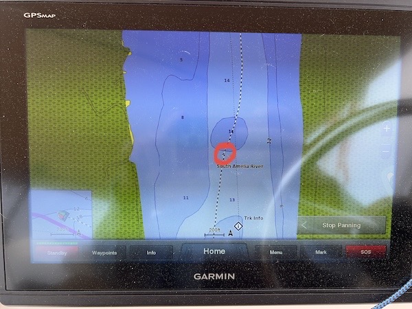
I took a photo of my track for where I grounded. If you look closely inside the red circle, you can see where the boat drifted backwards. I really wasn’t that far off the recommended track.
I was lucky. The tidal current was pushing me backwards and the tide was on its way up. I was grounded for less than 15 seconds. I let the boat drift backward at engine idle until the depth reading was 5 feet. Then I steered to starboard, shifted into forward idle, and slowly made my way back to the recommended track.
And that’s when I saw the tow boat coming in to get that sailboat off the shoal. It wasn’t anchored. It was grounded.
Captain Bob423 and his ICW Tracks
Of course, I’d heard about the Bob432 ICW tracks. Everyone knew about them. They were supposed to be the ultimate guide for traveling on the ICW. Bob cruises the ICW annually, letting his chartplotter record tracks of his travels. These tracks are known good — after all, he was able to travel on them — at least for the day he traveled on them. That’s why he shares updated tracks every time he makes them.
When I bought my boat in late August 2022, one of the first things I did (or thought I did) was to get a Garmin guy over to update the chartplotter and install updated charts. I know I paid him to do that. But as I realized in autumn 2023, the built-in charts weren’t updated since late 2018 when the Garmin units were installed. The “update” I’d paid too much money for was just a supplement that added data on top of the old data and enabled the Auto Routing feature of the system.
I learned this year that Garmin updates their charts for these units twice a year and if I want to keep them up to date, I have to spend $99 each time an update comes out, download the update using their software to get it on a SD card, and then keep that SD card in my chartplotter so the system can access it. I did that in November and will do it again in spring. Has this part of the chart changed at all? Damned if I know.
But I had so much confidence in my triple Garmin chartplotter setup. It told me how deep the water I was in was. I didn’t need Bob’s tracks. I was fine on my own.
Until I wasn’t.
My grounding incident rattled me, suddenly stripping away any confidence I had in my chartplotter data. If it said I had 13 feet and I had less than 2 1/2 feet (my draft), what else was wrong? Could I ever trust it?

Here’s a photo of my chartplotter screen while following my track in to get back out of Halfmoon Marina. Note the depth compared to what’s in the chartplotter image.
This question was answered with a resounding NO when I navigated up a river using local knowledge that directly contradicted my chart. At one point the chartplotter said I was navigating in a swamp when the depth indicator showed about 35 feet. I wrote about this when I began publishing my own tracks.
What could I trust, then? Well, it seemed as if the Bob423 tracks were a lot more trustworthy than the charts on my chartplotters. Maybe I should jump on board (pun intended) and install them on my boat.
So I did.
How to Download and Install the Bob423 Tracks on Your Chartplotter
I come from a computer background, so installing the tracks wasn’t a big deal for me. Download the tracks onto an SD card, pop the card into a chartplotter, and use the system’s convoluted menu system to copy them in. But I realize that a lot of folks just can’t figure this out. I blame Garmin. Their systems really aren’t user friendly.
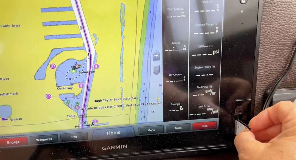
So yesterday I made a quick video to explain how I do this. In it, you’ll get to see how to download the tracks, open them in a GPX editing app (on a Mac; sorry Windows folks) to see what they look like plotted, copy them to an SD card, and install it on a Garmin GPSMap 7612 chartplotter. I then show you how you can check to make sure the track really was installed. The process should be very similar for most Garmin chartplotters with SD card slots.
Here’s the video:
(Hey, if you like the video, please click the Like button for it. And if you want more videos about cruising the Great Loop, click Subscribe. And if you think someone who writes informative blog posts and creates educational or entertaining videos should remain caffeinated, buy me a cup of coffee.)
I want to remind you that you should always download and install the latest version of a track you want to use. Don’t download today and expect them to be accurate three years from now.
You can find links to all the tracks and other resources on Bob423’s website, https://bobicw.blogspot.com/.
How I Use the Tracks
My boat navigation philosophy, which I think is an offshoot from my cockpit resource management skills honed over 20+ years as a helicopter pilot, is to take full advantage of my boat’s available tools to reduce my workload while driving the boat. That’s why I probably use my autopilot a lot more than the average cruising boater. I suspect that a lot of folks don’t really understand how it works or what it can do for them. I tried to educate people with a blog post about autopilot modes; if you’re hardly using your autopilot, I hope you’ll read it to see what you’re missing.
So after getting Bob423’s tracks loaded into my Garmin system, it wasn’t a far jump to tell my autopilot (“Otto”) to just follow the Bob423 (“El Capitan Roberto”) tracks. I’d get out onto the ICW pointed the right way, then call up the track I was on and tell Otto to follow it. Then I’d adjust my speed, settle down in my seat with a beverage of choice and a snack, and let Otto drive the boat with El Capitan Roberto’s explicit steering instructions.
Occasionally, when Bob423 had decided during his trip that he needed to leave the channel and there was a crab trap in front of me where he had driven that day or I when encountered another boat who seemed on or close to the track, I’d give Otto a break and manually steer around the hazard. Then I’d put Otto back to work and settle back into my seat again.
I basically did this from Fernandina to the turn for the Dismal Swamp on my way north and from Portsmouth to North Miami Beach (so far) on my way south. Thousands of miles. It takes all the navigational stress out of driving the boat because El Capitan Roberto always tells Otto the right way to go at those confusing intersections.
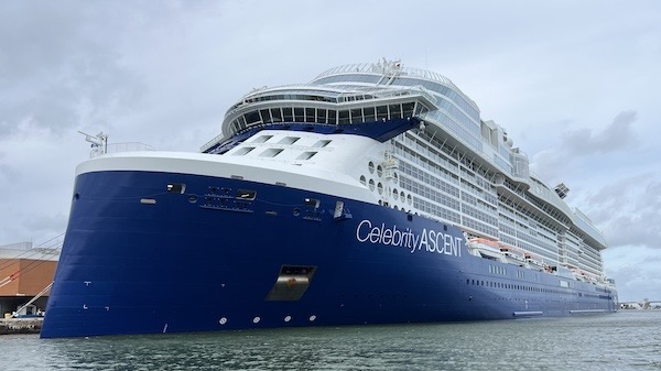
Now I don’t want you to think that the Bob423 tracks are perfect. They’re not. Things change. I came upon dredging operations and temporary channel markers that steered me off the tracks. Yesterday, if I’d stuck on the track on my way through the Fort Lauderdale cruise ship area, I would have been skimming the side of a Celebrity cruise ship. After all, the tracks were good the day Bob423 drove them; a storm at an inlet can easily change the adjacent shoaling. But my experience so far is that they are at least 90% reliable — a lot more reliable than my chartplotter data.

I suspect this was not here when Bob423 drove through the area. His track runs remarkably close to the ship’s port side.
Remember, no matter what you use to navigate, you are the captain and are ultimately responsible for the safe passage of your vessel.
What Do You Think?
What do you think about the Bob423 tracks? Do you use them? How? Please share your comments on this post so we can all learn from them.
And if you’re cruising north on the ICW starting on January 1, I hope you’ll look me up. I’m on Nebo: Do It Now.


Great write up and advice. Also very good cautioning the possible changes, even after Bob saved his track. Things change quickly where storms and tides are involved.
Thanks for what you do for the boating community by writing up this type of information in a legible manor. 🙂
Thanks so much for your kind words! I believe information should be shared in a place where everyone can benefit from it without having to belong to a for-profit organization. I’m learning so much as I cruise and really do want to help new cruisers have a save, enjoyable voyage. I’m also hoping folks will use the comments feature here (as you did) to share their own insight.
As for the video, I’ve decided to redo it. I can do better and will. The new one will replace the one that’s here as soon as it’s done.
Ditto on the great write up. I have not made a boat passage IVO Fernandina Beach, but I have recently flown a small plane around the island and could easily see the shoaling you experienced. As a helo pilot you can certainly appreciate the vantage point of 500-800 feet AGL. My sister has a beach house there and we flew a tourist lap around the island. It was actually my last trip as I recently sold my DA-20 – one less toy before starting the Great Loop. My two thoughts are #1. check Garmin’s Tide/Current page and try and transit areas of shoaling on a rising tide – and #2. the keel of the Ranger Tug is nicely designed to keep through-hull intakes and the inboard Volvo Penta propeller clear and protected. Much of FL is “soft bottom” so if you are not bouncing on the bottom in a wave/swell – don’t panic, it is simply lunch time until the tide rises. I own a RT31 now, but my previous boat was a sailboat with a full keel with 5’8″ draft. Lunch happened much more frequently (including inside the ICW channel) with that draft….