December 17, 2022: We make the final push to Mobile Bay and take a “shortcut” that didn’t save any time at all.
(continued from Silas, AL (Bobby’s Fish Camp) to North Mobile, AL (Tensaw River Anchorage))
I slept remarkably well at the anchorage. I think I had the completely quiet surroundings and my anchor alarm app to thank for that.
A Word about Anchor Alarms
I must have mentioned anchor alarms in a previous post, but I probably didn’t go into any detail. Let me take a moment to do that now.
An anchor alarm is a must-have for any boater who anchors out. It basically keeps track of where you told it the anchor is or your boat should be and alerts you when your boat moves farther than it should. If your boat is moving beyond a radius you specify, your anchor is probably not holding.
My chartplotters and Aqua Map both include anchor alarms, but I don’t use either one of those. Instead, I use the iPhone app recommended by Glen Wagner, speaker at an anchoring seminar I attended at the Ranger/Cutwater Rendezvous back in September 2022: Anchor Pro. The reason I picked it? I have a huge amount of respect and trust for Glen’s knowledge, experience, and desire for simplicity in his cruising. He has the same boat I do, so I know he’s got good taste. [insert wink emoji here]
In a perfect world, I’d stand on the bow pulpit as the anchor was dropped so I could mark the exact spot the anchor hits the mud or sand below the water. I’d then play out the amount of anchor rode I needed to secure the boat. That’s the limit I’d set for the boat’s movement. So if I let out 50 feet of rode, the limit would be 50 feet, right? After all, the boat shouldn’t move more in any direction than the amount of line between the anchor and the boat.
Of course, I don’t live in a perfect world. At that point, working with crewmembers, I’d usually be at the helm, prepared to move the boat if things went badly or back down on the anchor to help secure it. And I was too mentally occupied watching what the crewmember was doing and how the boat was reacting to set the exact dropping point of the anchor. So in most cases, I’d set the anchor alarm after the boat was already anchored and I was relatively sure we weren’t dragging. So I’d set our current location at the end of the anchor rode and then account for swinging. 50 feet of rode out? Well, we could drift back over the anchor (50 feet away) or beyond it (another 50 feet). So I’d set the limit to 100 feet, perhaps with 10 feet or so of wiggle room. This was not nearly as precise, but it works fine for me (so far).
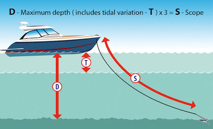
This image from the Club Marine website article about anchoring helps illustrate that anchoring isn’t as straightforward as the average non-mariner might think.
And yes, I realize that this discussion is not taking into consideration the depth of the water and the fact that the distance between the anchor and the surface is at an angle and that actually shortens the limit (see image). And I also realize that the first 50 feet of my rode is heavy chain so in situations with little or no current, that chain could get piled up on the bottom, further shortening the distance between the anchor and the boat. But this is not very important when setting an anchor alarm. All you need is something loud that will wake you up in the middle of the night if the boat starts to move beyond where it should be.
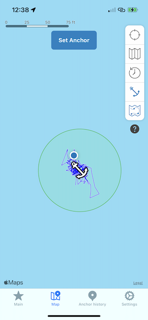
Here’s the map just after midnight. (Yes, I slept well, but that doesn’t mean I didn’t wake up to check the anchor.)
And if you think an anchor alarm is only useful when anchoring, think again. Later in my travels I set one when I was attached to a mooring ball — and became very glad I did.
Anyway, we were in a pretty stiff current so I played out lots of rode. The shallower the angle of the scope between the anchor and the boat usually makes the anchor hold better. I probably had more than 150 feet of rode out, looking for a 1:7 scope. The anchor alarm never sounded. We didn’t drift much, as the map image from Anchor Pro shows.
Weighing Anchor — or Trying To
The texts started coming just after 6 AM. GypSea was eager to move on. Chasing This said they’d follow. I was surprised they were all up and ready to go so early — after all, we’d left Bobby’s at about 9 the morning before — so I hurriedly said we’d be ready in 15 minutes. They said they’d wait at the mouth of the river.
Alyse and I scrambled to get ready to go. I started the engine — again, I needed to use the parallel switch to get enough juice to do the job — and gave her the signal. On the bow, she hit the Up switch for the windlass. Everything seemed to go well for a while and then it stopped. “It’s stuck again,” she called out.
Crap crap crap crap crap.
Well, at least it wasn’t raining.
We switched places. Sure enough, the line had jumped the little pulley again. I got down on my belly on the bow. Chasing This cruised past slowly, heading for the mouth of the river. GypSea was already almost there.
Using the hand signals from a few days before, I directed Alyse to use the throttle and bow thruster to give me the slack I needed to get the line back over the pulley. It only took about three tries. Then I used the windlass to get the rode and anchor stowed.
Of course, the boat began drifting as soon as the anchor was off the river bottom. I hurried back to the helm. My seat was empty. I climbed on, pushed the throttle forward, and hurried to catch up with my two buddy boats.
The one thing I regret about our short stay at the Tensaw River anchorage is that I never took any photos. This was a beautiful, pristine section of the river that seemed to be made for a boat to spend a few days on the hook. It wasn’t perfect for me — I really need someplace with shore access for my pups — but I have nothing but nice things to say about it. If you boat through there on your Loop, I highly recommend it.
The Mobile River
I followed GypSea and Chasing This back into what had become the Mobile River five statute miles upstream from the Tensaw confluence and we continued downstream. I have zero notes (or photos) for that part of the day — my log book page is basically blank — but I do have scattered memories. The weather was okay, although wind was forecast for Mobile Bay later that afternoon. We passed some tows, but not as many as I expected. The river wound back and forth a bit, but was definitely southbound. The course was narrow without much need for channel markers. We’d entered an area of brackish water where the river’s flow met with incoming salt water on the rising tide.
Surprisingly, there wasn’t much debris. Or maybe I just didn’t notice it after two full days dealing with it. Dodging debris had become second nature. I’d developed a skill that I hope I never needed in the future.
Our destination for the day was Fairhope City Docks. Yes, I’d made a reservation at a marina at Dog River, but Connie in La Principessa and Kim in Pony had really raved about Fairhope. It was a great little town, they said. Lots of shopping and restaurants. I needed something like that. I needed something beyond a marina with nothing much to offer other than cold restrooms and a place to plug in. I was tired of spending all my time on the boat with a companion who never seemed to be happy.
It was clear from satellite images that there was nothing at all like that near the Dog River marinas south of Mobile. In fact, they appeared to be in an industrial area, with lots of boat yards and a causeway bridge. It was isolated and I was sick of that. To make matters worse, it was on the west side of Mobile Bay, so I’d have to cross the bay to get to Fairhope, where I really wanted to go. So why not just skip Dog River and go right to Fairhope? Cross the bay on the north end, where it was less likely to have rough water on a windy day?

Here’s the Mobile area with both Dog River and Fairhope pointed out. We’d originally planned to come down the Mobile River right through downtown Mobile.
So I’d changed my reservations. I know Alyse wasn’t happy about it. Her destination was Mobile Airport and Dog River was closer to the airport than Fairhope was. But I’d gotten to the point where I was tired of making plans for other people. I wanted to make plans for myself. If the cost of an Uber to the airport was too expensive from Fairhope, I’d just rent a car and drive her.
In hindsight, I should have done that when we were in Columbus and Memphis was within driving distance. She could have made her December 15 doctor’s appointment and I could have taken my time coming down the river. Hindsight: always 20/20.
Chasing This was also going to Fairhope. So when Spencer got on the radio and advised us that he was turning off the river on a shortcut he’d found on Navionics, I told him I’d go with him.
It was not a good decision.
The “Shortcut”
First, I need to say that I don’t use Navionics. I prefer Aqua Map as my iPad-based trip-planning solution. A lot of people use Navionics and I think they do so because it was bought by Garmin and can interface with Garmin chart plotters. I looked at it and wasn’t impressed. I also didn’t want all my eggs in the Garmin basket, especially after my chartplotter’s Auto Guidance feature trying to kill me so many times. So I stuck to Aqua Map.
I vaguely remember trying to find a path to the east side of Mobile Bay in Aqua Map and not succeeding. I’d planned to go all the way down to the bay in the Mobile River and then finding a good place to cross as far north as I could. I’d even plotted out a course in Aqua Map for that day.
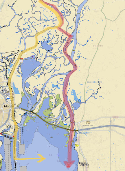
Here’s a comparison of the two routes. I’d planned the yellow route all the way down the Mobile River and then across to Fairhope. Navionics told Spencer he could take the red route, which followed a series of channels and streams into upper Mobile Bay on the east side.
But if Navionics had given Spencer a shortcut, I was game to follow it. I assumed he’d reviewed it and knew it would work for his boat. That meant it would work for mine.
You know what they say about assuming.
We ran into trouble almost immediately. At least Chasing This did. After taking the cutoff channel southeast to what Aqua Map identifies as the Tensaw River, he hit shallow water that put him at a standstill for a few minutes. It turns out that his draft is deeper than mine and because he has two engines instead of one, the hull does not protect his props. So while I was able to move in water as shallow as 2 1/2 feet, he needed more. Like 4 feet, I think.
This is where we should have turned around. We were following Navionic’s recommended route to get where we were going and had already encountered shallow water.
But the lure of a shortcut was hard to ignore. When he got under way again and I didn’t have any problems at all, we continued on with me behind him.
The charted depths in that area ranged from 7 feet to 36 feet. I didn’t encounter any water that worried me. I don’t think he did at that point either. So we just kept going south.
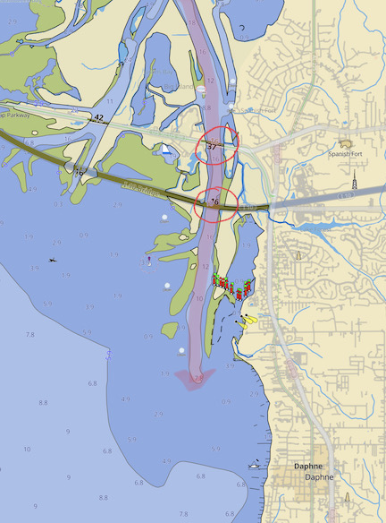
Here’s the end of the “shortcut” route and the reason I didn’t originally plan to go that way. At the south end of the river is an area of very shallow water (dark blue). I didn’t notice the bridges (circled) that we’d have to pass under.
It was around this time that I started looking ahead on Aqua Map. I clearly remembered exploring this in the app as a possible route, but what had stopped me was the shallow water at its end, where the river joined Mobile Bay. Aqua Map showed areas with depths as low as 0.9 feet. But maybe Navionics had better data or a specific route through the shallows? Like an idiot, I just kept following.
The route was peaceful and scenic. The water was calm. There was a lot of marshland and a few homes and businesses, all with small boat docks. We saw a handful of fishing boats speeding this way and that; I doubt any of them drew more than a foot of water. There were no boats our size. The people watching us pass must have been snickering at the idiots passing through.
What I hadn’t noticed on Aqua Map was the two bridges we’d have to pass under. The reason I didn’t notice them is because I’m accustomed to seeing Waterway Guide bridge icons for each bridge. These bridges weren’t in Waterway Guide. That was not a good thing.
As we approached the first bridge, I tried frantically to get clearance information for it. I finally found it on my chartplotter and confirmed it in Aqua Map: 16 feet. This was not a draw bridge. We’d have to fit under it.
According to Ranger Tug, my boat’s mast-up bridge clearance is 13’11” (or 14 feet). I added a Bimini top that I believe increases that by about a foot, so I always use an absolute minimum bridge clearance of 15 feet. Beyond that, I had a VHF antenna that was about another foot taller. That could be easily lowered from the command bridge without tools. I also had a windsock on a tall pole, but that had already been lowered to about the height of the antenna. So I had a boat that needed about 16 feet of clearance and two bridges in front of me that had published clearances of 16 feet.
It was going to be close.
I wasn’t worried about the antenna or the windsock. I was worried about that Bimini top, which had cost nearly $3,000 to install in September. I did not want to destroy its frame. I wasn’t worried about the mast because even if the published clearance was wrong, would it be wrong by 2 feet?
(I have since learned that yes, published clearances can be wrong by more than two feet. Fortunately, I have not learned the hard way.)
Chasing This drove right under the first bridge. No problem. Plenty of clearance. I followed, holding my breath and ducking (as one does) inside the cockpit. We passed under without any problem.
But the next bridge looked lower. I decided to go up and lower the antenna and windsock a bit. I put the boat into a circle pattern at forward idle using the autopilot. I told Alyse to sit at the helm and it we got too close to the bridge she should push the red Standby button and steer us away. She seemed to understand. Then I went out and upstairs to lower the antenna and windsock.
It had gotten windy and gray (of course) while we were cruising. I put all my attention to the task at hand. Antenna first, then windsock. Both needed to be below the height of the Bimini top, which was as low as it could be without using tools. I was completely focused on the task at hand.
So imagine my surprise when I looked up and saw the boat heading right for one of the bridge supports less than 50 feet away!
I yelled, I screamed, I cursed. I had a crewmember with instructions sitting at the helm and she wasn’t doing a damn thing. I ran down the stairs and into the cockpit, still yelling. I arrived just as she was pushing the red button. She got out of the seat, I turned the wheel hard, and I added throttle to drive us away from the bridge.
I was seething.
I steered us upriver for a short while and then turned around. I could see Chasing This on the other side of the bridge, continuing away from us. I picked a spot, aimed the boat toward it, and slipped under the bridge. It was all okay. I focused on trying to calm down, reminding myself that we’d soon be in Fairhope.
But of course, we weren’t out of the woods yet. Chasing This, up ahead, had come to a stop. Too shallow, Spencer reported over the radio. (We’d switched to channel 68 earlier in the day to communicate without texting.) He wasn’t sure he could get through.
So there wasn’t some special Navionics track that navigated through this? Navionics had really recommended a route with less than a few feet of depth part of the way? What kind of crazy bullshit was that? Was everything Garmin owned trying to get unsuspecting boaters in trouble?
We had already gone at least 15 or 20 miles from the Mobile River. I did not want to go back. I did not want to go under those two bridges again. I did not want to add hours to my trip.
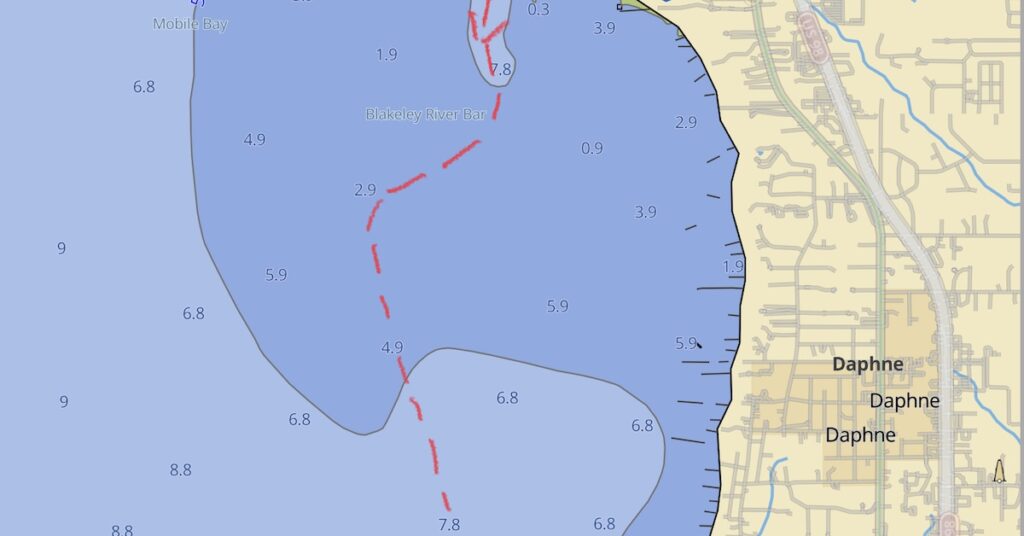
I looked at my depthfinder’s readout. Yes, it was shallow. But I also knew that whatever number it displayed, I had at least 3 feet of “wiggle room.” I’d seen it display depths as low as -0.9 feet and I’d been able to get through without dragging anything. I figured I could move on slowly and keep an eye on the depthfinder. I’d stop when it got to less than -0.9 feet.
But before I did that, I stepped outside and used my boathook to dip into the water to touch the ground. I compared that depth to what I saw on the depth finder. I’d done this exercise before at the IVY Club in Peoria Heights. Yes, I confirmed that I had at least 3 feet more water than what the depth finder said.
My chartplotter had depths plotted on it. I figured that if I could steer the boat to the deepest water closest to the boat, I might be able to find a path through. Heck, it was only a few hundred feet to charted deeper water. I had to try.
What’s the worst that could happen? I could get grounded in what seemed to be a sand/mud bottom. No damage to the boat. No damage to the prop if I stopped it right away. The tide swing wasn’t much there, but it was currently low. That meant the only place I could go was up.
With all that reasoning in my mind, I tapped the 2.9 feet depth indicator on the chartplotter and tapped the GoTo button. I engaged the route and the boat started steering us, at idle forward speed — 3 knots? — through the shallows.
I’m not exaggerating when I say that it took at least 20 minutes to go just a few hundred feet. I watched the depthfinder’s readout. It got as low as -1.1 feet before it started climbing again, but it was in minus territory for far longer than I ever want to see again. When we reached the 2.9 foot indication on the chart, I tapped a 4.9 foot indication and hit GoTo again. The boat turned — right toward a row of crab traps.
Yes, shallow water wasn’t bad enough. Not only did I have to get through that, but I had to navigate around crab trap buoys. Running over one of those would stop us dead by entangling the prop in nylon rope that would have to be manually cut off. Swimming was not on my list of things I wanted to do that day.
In the meantime, Chasing This had given up. They turned around and headed back the way we’d come. We were on our own.
I breathed a heavy sigh of relief when the depthfinder started showing positive depths, especially since only deeper water lay ahead of us on the chart. I tapped the 7.8 indicator on the chartplotter and hit GoTo. The boat changed course. A moment later, the depth finder was showing 3 feet and was climbing.
We’d made it through.
But did I learn a valuable lesson that day? Hell yes! The lesson is this: never follow another captain, no matter how experienced you think he might be, unless you review the entire route to look for potential hazards or other problems. I am the captain of my boat. There’s absolutely no reason why I should let someone else make decisions for me.
And yes, that goes for the entire floodwaters trip. I’m not saying I wouldn’t do it or that it was a bad decision. It worked out okay, and certainly did test my skills. But it’s clear to me that I would not have left Demopolis on my own that morning and that makes me wonder exactly who was making the decisions then.
Arriving at Fairhope
I steered a course down Mobile Bay’s east shore, staying out of the shallow areas and dodging crab trap buoys. The wind was out of the west and it had really whipped up some waves that hit us abeam as we went south. The boat rocked back and forth a lot more than it had before on this part of the trip — or maybe on this trip at all. I sped up. The sooner we got to the channel for the marina, the sooner I could turn east and have all the waves behind me.
And that’s pretty much how it worked. I aimed for the entrance to the channel and then turned in. The waves, now behind us, pushed us forward. I slowed down and entered the marina basin. The rough water didn’t quite end, but it was a lot smoother than it had been.
I had some trouble, at first, finding where I was supposed to go. Finally, I saw a covered slip on the end of a row of slips. It was a fixed dock and, it being low tide, the dock was higher than the boat’s gunwales. Cleats were on side posts instead of on the dock. I got the boat into the slip, brought it to a stop, and used the side thrusters to bring us against the dock posts. Then I took the midship line, wrapped it around a post, and hitched it to a cleat. I did the same with bow and stern lines.
I wasn’t happy that the boat was still being tossed around by waves that had somehow gotten into the marina basin, but I was thrilled to be parked in the Mobile area.
Our long run down the Tombigbee River was done. We’d arrived in the Mobile area two days before planned, helped along by the floodwater current. We’d done 197.2 miles in just 3 days of travel.
Chasing This arrived at the marina three hours later.
(continued in At Fairhope, AL)

And again, nice job Maria! “Cockpit Resource Management” applies to just about everything. “Briefing the departure” and cruise etc. Good educational trip here! 👍👍
I sure learned a lot. I think Spencer did, too.
In all honesty, this isn’t the first time Navionics has recommended a bad route to someone I know. Apparently, it does it quite often. Most folks review the route instead of just accepting it. Going 3 hours out of your way because of a bad route suggested by a navigation app is enough to convince me not to blindly accept any of its suggestions.
Do you have an anchor bridle? If not, I’d suggest one. It’ll take the regular strain off the bow roller, and therefore make it easier to get the load off the rode at the roller so you can get it back onto the roller (if it even hops off once you’re using a bridle). Mantus Marine makes a good example, but I’ve also seen people use just a piece of line.
As the navigation goes, have you experimented with creating your own waypoints and building a manual route from waypoint to waypoint? That’d let you manually check your route for (charted) hazards before loading it, and then “know” (we hope) that the Garmin stuff won’t throw a zig-zag out of nowhere.
I do have an anchor bridle, but I haven’t used it yet. Instead, I figured out why the rode was jumping the roller and adjusted it so it doesn’t do it anymore.
Yes, with 112 days on the Loop (as of today), I’ve run all of my navigation equipment through the mill. Auto Guidance is only usable if the entire route is checked and modified, either in advance or along the way. Manually creating a route is very good but also very time consuming for a long route. No matter how I use autopilot, I need to periodically disable it to steer around other traffic, crab pots, or other hazards. It’s nice when the boat steers itself, but it doesn’t reduce the workload much when you have to keep watching it closely to make sure it works the way you expect. Still, I keep experiementing with it. Heading Hold is every boater’s friend.